California
Berkeley and Chez Panisse
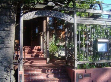
Chez Panisse opened its doors in 1971, started by Alice Waters and an assortment of idealistic friends. A neighborhood bistro named after a character in Marcel Pagnol's 1930's trilogy of movies (‘Marius,’ ‘Fanny,’ and ‘Cesar’), the Restaurant and Café are a homage to the sentiment, comedy and informality of these classic films.
From the beginning, Alice and her partners tried to do things the way they would like them done at a dinner party at home. The restaurant, located downstairs, is open for dinner Monday through Saturday, by reservation only. The dinner, served in two seatings from 6 to 6:30 p.m. and 8:30 to 9:30 p.m., has always consisted of only one fixed-price menu, of three to four courses. The menu changes every night, designed to be appropriate to the season and composed to show off the finest ingredients obtainable including meat, fish, and poultry.
Prices for the Restaurant are $60 Mondays, $75 Tuesdays through Thursdays and $95 Fridays and Saturdays, not including beverage, a 17% service charge and 8.75% tax. Monday night menus are generally simpler and more rustic or regional than what the restaurant serves on other evenings. Friday and Saturday night menus are somewhat more elaborate.
The Café at Chez Panisse, located upstairs, opened in 1980 to offer an alternative to the set menu served in the Restaurant downstairs. The Café offers a moderately priced à la carte menu for both lunch and dinner. The Café lunch hours are Monday through Saturday 11:30am -3:00pm. Dinner hours are Monday through Thursday at 5pm - 10:30pm, and Friday through Saturday at 5pm -11:30pm. It has an open kitchen along one side of the room with a charcoal grill and a wood burning oven. The style of the menu is inspired by the market; consequently, the menus change every day. Reservations are recommended.
Alice and Chez Panisse have become convinced that the best-tasting food is organically grown and harvested in ways that are ecologically sound, by people who are taking care of the land for future generations. The quest for such ingredients has largely determined the restaurant's cuisine. Chez Panisse has tried for years to make diners here partake of the immediacy and excitement of vegetables just out of the garden, fruit right off the branch, and fish straight out of the sea. In doing so, Chez Panisse has stitched together a patchwork of over sixty nearby suppliers, whose concerns, like the restaurant's, are environmental harmony and optimal flavor.
Carmel-By-The-Sea
Carmel-by-the-Sea, usually called simply Carmel, is a small town endowed with a rich artistic history situated on the Monterey Peninsula in Monterey County, California. In 1906, the San Francisco Call devoted a full page to the "artists, poets and writers of Carmel-by-the-Sea" and in 1910 it reported that 60 percent of Carmel's houses were built by citizens who were "devoting their lives to work connected to the aesthetic arts." Early City Councils were dominated by artists and the town has had several mayors who were poets or actors including Herbert Heron, founder of the Forest Theater, and actor-director Clint Eastwood, who was mayor for one term, from 1986 to 1988. Currently, the mayor is Sue McCloud, who is in her record-setting fifth 2-year term. Before returning to her childhood home upon retirement, she was the station chief in Geneva, Switzerland for the U.S. Central Intelligence Agency. As of the 2000 census, the town had a total population of 4,081. When referring to this city or its attributes, the name Carmel is pronounced "car-MEL".Carmel Arts and Crafts Club In 1905, in an effort to foster the arts, the Carmel Arts and Crafts Club was formed. After the 1906 San Francisco earthquake the village received an influx of artists and other creative types escaping the disaster area. Jack London describes the artists' colony in a portion of his novel, The Valley of the Moon; among the noted artists who thrived here were Mary Austin, Armin Hansen, George Sterling, Robinson Jeffers, Sinclair Lewis, Sydney Yard, Ferdinand Burgdorff, William Frederic Ritschel, William Keith and Percy Gray.
Arts and Crafts Clubhouse/Golden Bough Playhouse In 1906-07 the town's first cultural center and theatre, the Carmel Arts and Crafts Clubhouse, was built.[2] Poets Austin and Sterling performed their works there. A theatre program was initiated and numerous plays and recitals were given. By 1913, The Arts and Crafts Club had began organizing lessons for aspiring painters, actors & craftsmen. Some of the most prominent painters in the United States, such as William Merritt Chase, Mary DeNeale Morgan and C. Chapel Judson offered six weeks of instruction for $15. The original clubhouse, along with an adjoining theatre built in 1922, burned down in 1949 after a production of "By Candlelight". The site, which has been declared historic, is now home to the Golden Bough Playhouse, built in 1951. It is owned and operated by Carmel's only professional theatre, Pacific Repertory Theatre, founded in 1983 by Carmel resident, Stephen Moorer.
Carmel sunset over the PacRep/Carmel Shakespeare Festival production of Julius Caesar at the Forest Theater.
Forest Theater In 1910, the Forest Theater, the first outdoor theater west of the rockies, was built, with poet Mary Austin and actor/director Herbert Heron leading the endeavor. Numerous groups, including the Forest Theater Society and the Western Drama Society, presented plays and pageants. Original works and the plays of Shakespeare were the primary focus. The property was deeded to the City of Carmel-by-the-Sea in order to qualify for federal funding and, in 1939, the site became a WPA project. After several years, the site re-opened as The Carmel Shakespeare Festival, with Herbert Heron as its Director, and, with the exception of the WWII years of 1943-44, the festival continued through the 1940s.
In 1949 the Forest Theater Guild was incorporated, and under the leadership of Cole Weston, the 60-seat indoor Forest Theater was created. For most of the 1960s, the outdoor theater lay unused and neglected. In 1968, Marcia Hovick's Children's Experimental Theater leased the indoor theater and continues today. In 1972 the Forest Theater Guild was reactivated and continues to produce musicals, adding a film series in 1997. In 2006, the Guild presented the California community theatre premiere of Andrew Lloyd Webber's musical, Cats, based on T. S. Eliot's "Old Possums Book of Practical Cats".
In 1984, Pacific Repertory Theatre began producing on the outdoor Forest Theater stage, reactivating Herbert Heron's Carmel Shakespeare Festival in 1990. In 2005, PacRep presented the facility's highest-attended production, Disney's Beauty and the Beast, to a combined audience of over 10,000 ticket holders.
Robinson Jeffers' Tor House and Hawk Tower Main article: Tor House and Hawk Tower In 1914, when they first saw the unspoiled beauty of the Carmel-Big Sur coast south of California's Monterey Peninsula, poet Robinson Jeffers (1887-1962), and his wife, Una (1884-1950), knew they had found their "inevitable place." Over the next decade, on a windswept, barren promontory, using granite boulders gathered from the rocky shore of Carmel Bay, Jeffers built Tor House and Hawk Tower as a home and refuge for himself and his family. It was in Tor House that Jeffers wrote all of his major poetical works: the long narratives of "this coast crying out for tragedy," the shorter meditative lyrics and dramas on classical themes, culminating in 1947 with the critically acclaimed adaptation of Medea for the Broadway stage, with Dame Judith Anderson in the title role. He called his home Tor House, naming it for the craggy knoll, the "tor" on which it was built. Carmel Point, then, was a treeless headland, almost devoid of buildings. Construction began in 1918. The granite stones were drawn by horses from the little cove below the house. Jeffers apprenticed himself to the building contractor, thus learning the art of making "stone love stone." Construction was completed in mid-1919.
In 1920, the poet-builder began his work on Hawk Tower - a retreat for his wife and sons. It was completed in less than four years, a remarkable feat since Jeffers built the tower entirely by himself. He used wooden planks and a block and tackle system to move the stones and to set them in place. Many influential literary and cultural celebrities were guests of the Jeffers family. Among them were Sinclair Lewis, Edna St. Vincent Millay, Langston Hughes, Charles Lindbergh, George Gershwin and Charlie Chaplin. Later visitors have included William Everson, Robert Bly, Czesław Miłosz and Edward Abbey.
Aimee Semple McPherson Aimee Semple McPherson in her "Gospel Car", 1918 Carmel figured in a 1926 scandal involving radio evangelist Aimee Semple McPherson, who vanished for a period of time, claiming to have been abducted. Several witnesses reported having seen her in Carmel together with broadcasting colleague Kenneth Ormiston during the time she was missing, and a grocery receipt signed by McPherson was discovered in a Carmel cottage.
Carmel Art Association Gray Gables at Lincoln and Seventh was the birthplace of the Carmel Art Association, founded by artists Josephine Culbertson and Ida Johnson. This small group nurtured art, primarily through the auspices of the Carmel Arts & Crafts Club, until 1927, when a breakthrough meeting took place, and the group committed to building an exhibition gallery to display their works. Their first show with 41 artists took place in October of the same year in the Seven Arts building of Herbert Heron. The permanent gallery was completed in 1933 at its present location on Dolores Street. In the early 1930s the tiny group claimed four members who had attained the status of membership in the National Academy of Design.
Carmel Bach Festival The Carmel Bach Festival began in 1935 as a 3 day festival of concerts, and now encompasses 3 weeks of concerts. These concerts link historical performance practices and a rediscovery of Baroque music. Currently, the Festival is under the leadership of Jesse Read, who started as a performer with Carmel Bach in 1980. The 3 weeks of performances include concerts, recitals, master classes, lectures sumposia and other programs in various venues through-out the town of Carmel.
Monterey Symphony Considered one of California's premiere symphony orchestras[citation needed], the Monterey Symphony provides triple performances of a seven concert series as well as an extensive education program and special performances. It was founded in December 1946 in the Carmel home of its first president Grace Howden. It is currently led by Spanish conductor Max Bragado Darman who joined the orchestra in 2004. The music directors of the Monterey Symphony are Lorell McCann (1947-1953) and Clifford Anderson (1947-1954), Gregory Millar (1954-1959), Earl Bernard Murray (1959-1960), Ronald Ondrejka (1960-1961), John Gosling (1961-1967), Jan De Jong (1967-1968), Haymo Taeuber (1968-1985), Clark Suttle (1985-1998), Kate Tamarkin (1998-2004), and Max Bragado Darman (2004 to present).
Carmel Pine Cone See also: Media in Monterey County The Carmel Pine Cone is the town's weekly newspaper and has been published since 1915, covering local news, politics, arts, entertainment, opinions and real estate. The newspaper also has a section called The Police Log that contains almost every report of a crime in the Carmel area, often read with a quaint twist of humor by readers since the contents of the log are fairly innocuous. Veteran CBS and NBC network news producer Paul Miller became publisher in 1997. In 2005, after failing to convince city officials to rezone a potential site for the Pine Cone's operation, he moved the paper's production offices to Pacific Grove, while maintaining a reduced news staff in downtown Carmel. In 2007, the paper began offering a Adobe Acrobat (*.PDF) version of its complete newspaper on the Internet, giving readers a chance to keep up with local news online.
Hollywood
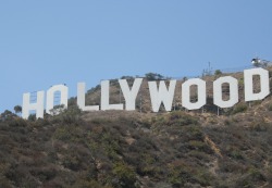
Hollywood is a district in the city of Los Angeles, California, situated west-northwest of Downtown Los Angeles.[1] Due to its fame and cultural identity as the historical center of movie studios and movie stars, the word "Hollywood" is often used as a metonym of cinema of the United States. The nickname Tinseltown refers to the glittering, superficial nature of Hollywood and the movie industry.[2] Today, much of the movie industry has dispersed into surrounding cities such as Burbank and the Los Angeles Westside[3] but significant auxiliary industries, such as editing, effects, props, post-production and lighting companies, remain in Hollywood.
Many historic Hollywood theaters are used as venues and concert stages to premiere major theatrical releases and host the Academy Awards. It is a popular destination for nightlife and tourism and home to the Hollywood Walk of Fame.
Although it is not the typical practice of the city of Los Angeles to establish specific boundaries for districts or neighborhoods, Hollywood is a recent exception. On February 16, 2005, Assembly Members Goldberg and Koretz introduced a bill to require California to keep specific records on Hollywood as though it were independent. For this to be done, the boundaries were defined. This bill was unanimously supported by the Hollywood Chamber of Commerce and the LA City Council. Assembly Bill 588 was approved by the Governor on August 28, 2006 and now the district of Hollywood has official borders. The border can be loosely described as the area east of Beverly Hills and West Hollywood, south of Mulholland Drive, Laurel Canyon, Cahuenga Boulevard, and Barham Boulevard, and the cities of Burbank and Glendale, north of Melrose Avenue and west of the Golden State Freeway and Hyperion Avenue. This includes all of Griffith Park and Los Feliz—two areas that were hitherto generally considered separate from Hollywood by most Angelenos. The population of the district, including Los Feliz, as of the 2000 census was 167,664 and the median household income was $33,409 in 1999.[4]
As a portion of the city of Los Angeles, Hollywood does not have its own municipal government, but does have an official, appointed by the Hollywood Chamber of Commerce, who serves as "Honorary Mayor of Hollywood" for ceremonial purposes only. Johnny Grant held this position for decades, until his death on January 9, 2008.[5][6]
Sunset Boulevard
Sunset Boulevard is a street in the western part of Los Angeles County, California, that stretches from Figueroa Street in downtown Los Angeles to the Pacific Coast Highway at the Pacific Ocean in the Pacific Palisades. The street is an icon of Hollywood celebrity culture and the phrase "Sunset Boulevard" is an enduring shorthand for the glamor associated with Tinseltown.
Approximately 22 miles (35 km) in length, the famous boulevard passes through or near Echo Park, Silver Lake, Los Feliz, Hollywood, West Hollywood, Beverly Hills, Holmby Hills, Bel-Air, Brentwood, and Pacific Palisades. It also passes through the neighborhood of Little Armenia on the East side of Sunset Boulevard. Other than West Hollywood and Beverly Hills, which are independent incorporated cities, the places named above are all districts and neighborhoods in the City of Los Angeles. In the Bel-Air district of Los Angeles, Sunset Boulevard runs along the northern boundary of the UCLA Westwood campus.
The boulevard is winding and treacherous in some areas. It is at least four lanes in width for all of its route. Car accidents are not uncommon due to its numerous hairpin curves and blind crests, and the lack of a center divider on most sections. Sunset (along with Santa Monica and Wilshire Boulevards) is frequently congested with traffic loads far beyond its design capacity. As a result, it is also notorious for cracks and potholes. Traffic on Sunset is often slow-moving, with bumper-to-bumper congestion not infrequent during rush hour in both directions. However, when traffic is mild or nonexistent, Sunset is an extremely fast thoroughfare as it encounters few (and short timed) traffic lights west of Doheny Drive. Even at rush hours, traffic generally flows well through the Holmby Hills and Bel Air, west of Whittier in Beverly Hills, as the lights are very well spaced and timed.
Sunset Boulevard used to extend farther east, starting at Alameda Street near Union Station and beside Olvera Street in the historic section of Downtown, but the portion of Sunset Boulevard east of Figueroa on the north end of Downtown Los Angeles was renamed César E. Chávez Avenue, along with Macy Street and Brooklyn Avenue, in honor of the late Mexican-American trade union leader.
In the 1970s the area between Gardner Street and Western Avenue, became a seedy red-light district afflicted with street prostitution. It was at the corner of Sunset and Courtney Avenue that actor Hugh Grant pulled over and picked up prostitute Divine Brown in the early morning of June 27, 1995. He then drove a few blocks east and parked at the corner of Curson and Hawthorn Avenues. Police arrested him and the prostitute for lewd conduct in a public place and he was later fined $1,200. Shortly after this police raids drove out the majority of prostitutes in this area and the majority of those turned to on-line escort services, thus diminishing the long held red-light district.
The Guitar Center in West Hollywood Sunset Boulevard in Hollywood is also sometimes called "Guitar Row" due to the large number of guitar stores and music industry-related businesses, including the legendary recording studios Sunset Sound Studios and United Western Recorders. Also, many young, struggling actors, musicians, and other artists continue to live in the area.
The best-known section of Sunset Boulevard is probably the Sunset Strip in West Hollywood, which is a center for nightlife in the Los Angeles area.
The portion of Sunset Boulevard from the western city limits of Beverly Hills to its eastern end was at one time named Beverly Boulevard.
The boulevard is commemorated in Billy Wilder's famous movie, an Andrew Lloyd Webber musical, and a hit song in 2005 by Scott Grimes. 77 Sunset Strip was also the name of a 1950's television series. Jan and Dean's 1960's hit song Dead Man's Curve immortalizes a section of the road near Bel Air estates just north of UCLA's Drake Stadium. Disney's Hollywood Studios has a recreation of Sunset as a backdrop for its The Twilight Zone Tower of Terror and Rock 'n' Roller Coaster rides.[1]
Santa Monica and Venice
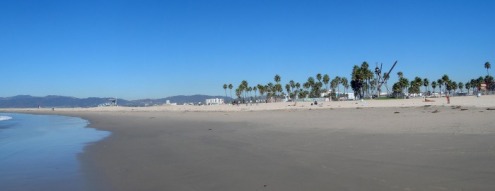
Venice is a district in western Los Angeles, California, United States. It is known for its canals, beaches and circus-like Ocean Front Walk, which features performers, fortune-tellers and vendors.[1] Throughout the summer months, the boardwalk is actively entertaining, and this tradition continues on weekends in the winter. [2] It is an important tourist attraction in Southern California, [3] and has retained its popularity in part because it is an attractive location for walking and bicycling. [2]. It was home to early Beat poets and artists in Los Angeles. [4] Its area codes are 310 and a 424 overlay. Its ZIP Code is 90291.Attractions and neighborhoods Venice is today one of the most vibrant and eclectic areas of Southern California and it continues a tradition of progressive social change involving prominent Westsiders. The Venice Family Clinic is the largest free clinic in the country.
Many of Venice's houses have their principal entries from pedestrian-only streets, and have house numbers on these footpaths. (Automobile access is by alleys in the rear). However, like much of Los Angeles, Venice is also well-known for traffic congestion. It lies 2 miles (3.2 km) away from the nearest freeway, and its unusually dense network of narrow streets was not planned for the demands of modern traffic. Mindful of the tourist nature of much of the district's vehicle traffic, though, its residents have successfully fought numerous attempts to extend the Marina Freeway (SR 90) into southern Venice
Venice Beach is understood to include the beach, the promenade that runs parallel to the beach ("Ocean Front Walk" or just "the boardwalk"), Muscle Beach, the handball courts, the paddle tennis courts, Skate Dancing plaza, the numerous beach volleyball courts, the bike trail and the businesses and residences that have their addresses on Ocean Front Walk. Many vendors line the boardwalk. Legend has it the tradition of vending on the boardwalk itself was started by local artist, Sponto.
Along the southern portion of the beach, at the end of Washington Boulevard, is the Venice Fishing Pier. A 1,310-foot (400 m) concrete structure, it first opened in 1964, but was closed in 1983 due to El Niño storm damage, only reopening in the mid-1990s. On December 21, 2005, the pier again suffered damage when waves from an unusually big northern swell caused the part of the pier upon which the restrooms was located to fall into the ocean.
Waves at the Pier, Dec. 21, 2005 The pier remained closed until May 25, 2006, when it was reopened after an engineering study concluded the pier was structurally sound.
The Venice Breakwater is an acclaimed local surf spot in Venice, located north of the Venice Pier and Lifeguard Headquarters, and south of the Santa Monica Pier. This spot is sheltered on the north by an artificial barrier, the breakwater, consisting of an extending sand bar, piping, and large rocks at its end.
This spot has differing breaks depending on swell intensity, swell direction, tide and time of the day. However, with intense swells such as those of the winter of 2005/2006, Breakwater boasts a clean left.
[edit] Downtown Venice The areas along Abbot Kinney and Grand Boulevards and Main Street form the traditional downtown of Venice. During the 1920s and 1930s, the area's nightlife was quite active, with thousands of Angelenos arriving every night by streetcar. (Before he burst onto the national scene, Benny Goodman had a brief residence as a bandleader in Venice). Nightlife boomed again in the late 1960s as the area became a center of hippie culture. Since the late 1990s, downtown Venice has been especially popular, with many bars, nightclubs, art galleries, and edgy apparel shops occupying both its older brick and Art Deco storefronts and hyper-modern glass facades.
[edit] Oakwood The Oakwood neighborhood of Venice, also known as Ghost Town and the "Oakwood Pentagon", which lies inland a few blocks from the tourist areas, is one of the few historically African American areas of in West Los Angeles, although Latinos have comprised the overwhelming majority of the residents. During the age of restrictive covenants that enforced racial segregation, Oakwood was set aside as a settlement area for blacks, who came by the hundreds to Venice to work in the oil fields during the 1930s and 1940s. After the construction of the 405 freeway passed through predominantly Mexican and immigrant communities, they moved further west and into Oakwood. Small numbers of Caucasian Americans moved in or around the Oakwood area during the 1980s and 1990s.
The Venice Shoreline Crips and the Latino Venice 13 gang, which are under a shaky truce, continue to remain active in Venice. The Venice White Boys, another gang, disappeared decades before the 2000s. By 2002, numbers of gang members in Oakwood were reduced due to gentrification and increased police presence. According to a Los Angeles City Beat article, by 2003, many Los Angeles Westside gang members resettled in the city of Inglewood [5].
Near the end of the 20th century, gentrification has greatly altered Oakwood. Although still a primarily Latino and African-American neighborhood, the neighborhood is in flux. According to Los Angeles City Beat, [6] "In Venice, the transformation is....obvious. Homes are fetching sometimes more than $1 million, and homies are being displaced every day." Author John Brodie challenges the idea of gentrification causing change and commented "...the gunplay of the Shoreline Crips and the V-13 is as much a part of life in Venice as pit bulls playing with blond Labs at the local dog park."[7] Xinachtli, a Latino student group from Venice High School and subset of MEChA, refers to Oakwood as one of last beachside communities of color in California. Chicanos and Latinos comprise over 50% of Venice High School's student body.[8]
[edit] East Venice East Venice is a racially and ethnically mixed, residential neighborhood of Venice that is separated from Oakwood and Milwood (the area south of Oakwood) by Lincoln Boulevard, extending east to the border with Mar Vista, near Venice High School. Aside from the commercial strip on Lincoln (including the Venice Boys and Girls Club and the Venice United Methodist Church), the area almost entirely consists of small homes and apartments as well as Penmar Park and (bordering Santa Monica) Penmar Golf Course. The existing population (primarily composed of non-Latino whites, Latinos, and Asians, with small numbers of other groups) is being supplemented by new arrivals who have moved in with gentrification.
A housing project, Lincoln Place, was built nearby by the Housing Authority of the City of Los Angeles to accommodate GI's returning from the war and in need of affordable housing. It later came to house working class families. Lincoln Place is currently in the midst of an extensive legal battle between past and present tenants and the owner, AIMCO. The developer, which acquired the property in 2003, plans to demolish it and build a mixed-use condominium and retail structure on the site. Only 13 tenants remain, all of them elderly or disabled.
Napa Valley
Napa County is a county located north of the San Francisco Bay Area in the U.S. state of California. It is part of the Napa, California, Metropolitan Statistical Area. As of 2000 the population is 124,279. The county seat is Napa. Napa County was one of the original counties of California, created in 1850 at the time of statehood. Parts of the county's territory were given to Lake County in 1861. The word napa is of Native American derivation and has been variously translated as "grizzly bear", "house", "motherland", "fish"[citation needed]. Of the many explanations of the name's origin, the most plausible seems to be that it is derived from the Patwin word napo meaning house[citation needed], although local residents will often cite an urban legend that gives the translation as "you will always return".
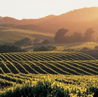
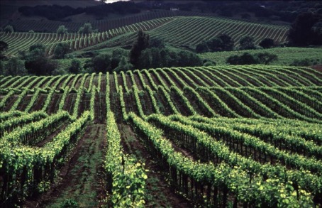
Napa County, once the producer of many different crops, is known today for its wine industry, rising in the 1960s to the first rank of wine regions with France and Italy.
Wine in Napa Valley Main article: Napa Valley AVA Napa Valley is most famous for its wine. Napa Valley is widely considered one of the top American Viticultural Areas in California, and all of the United States, with a history dating back to the early nineteenth century. By the end of the nineteenth century there were more than one hundred and forty wineries in the area. Of those original wineries several still exist in the valley today including Charles Krug Winery, Shramsburg, Chateau Montelena and Beringer. Viticulture in Napa suffered a setback when prohibition was enacted across the country in 1920. Furthering the damage was an infestation of the phylloxera root louse which killed many of the vines through the valley. These two events caused many wineries to shut down and stalled the growth of the wine industry in Napa County for years. Following the Second World War, the wine industry in Napa began to thrive again.
Robert Mondavi Winery, Napa In 1965, Napa Valley icon Robert Mondavi broke away from his family's Charles Krug estate to found his own. This was the first new large scale winery to be established in the valley since before prohibition. Following the establishment of the Mondavi estate, the number of wineries in the valley continued to grow, as did the region's reputation.
Chateau Montelena In addition to large scale wineries, Napa Valley's boutique wineries produce some of the world's best wines. The producers of these wines include but are not limited to: Araujo, Bryant Family, Colgin Cellars, Dalla Valle Maya, Diamond Creek, Dominus Estate, Duckhorn Vineyards, Dunn Howell Mountain, Grace Family, Harlan Estate, Husic, Kistler, Jericho Canyon Vineyards, Marcassin, Screaming Eagle, Shafer Hillside Select, Sine Qua Non, Spencer-Roloson Winery and Vineyard 29.
Today Napa Valley features more than three hundred wineries and grows many different grape varieties including Cabernet Sauvignon, Chardonnay, Merlot, Zinfandel, and other popular varietals. Napa Valley is visited by as many as five million people each year.
The Pacific Coast Highway and Big Sur
Big Sur is a sparsely populated region of the central California, United States, coast where the Santa Lucia Mountains rise abruptly from the Pacific Ocean. The terrain offers stunning views, making Big Sur a popular tourist destination. Big Sur's Cone Peak is the highest coastal mountain in the lower 48 states, ascending nearly a mile (5,155 feet/1.6 km) above sea level, only three miles (4.8 km) from the ocean.[1]
Although Big Sur has no specific boundaries, many definitions of the area include the 90 miles (145 km) of coastline between the Carmel River and San Carpoforo Creek, and extend about 20 miles (32 km) inland to the eastern foothills of the Santa Lucias. Other sources limit the eastern border to the coastal flanks of these mountains, only three to 12 miles (4.8-19 km) inland.
The northern end of Big Sur is about 120 miles (193 km) south of San Francisco, and the southern end is approximately 245 miles (394 km) north of Los Angeles.
Big Sur today Big Sur remains sparsely populated, with about 1000 inhabitants, according to the 2000 U.S. Census. The people of Big Sur today are a diverse mix: descendants of the original settler and rancher families, artists and other creative types, along with wealthy home-owners from the worlds of entertainment and commerce. Real estate costs are as impressive as the views, with most homes priced above $2 million. There are no urban areas, although three small clusters of gas stations, restaurants, and motels are often marked on maps as "towns": Big Sur, in the Big Sur River valley, Lucia, near Limekiln State park, and Gorda, on the southern coast. The economy is almost completely based on tourism. Much of the land along the coast is privately owned or has been donated to the state park system, while the vast Los Padres National Forest and Fort Hunter Liggett Military Reservation encompass most of the inland areas. The mountainous terrain, environmentally conscious residents, and lack of property available for development have kept Big Sur almost unspoiled, and it retains an isolated, frontier mystique.
The Basin Complex Fire of 2008 forced a two-week evacuation of Big Sur and the closure of Highway 1, beginning just before the July 4 holiday weekend.[14] The fire, which burned over 130,000 acres, represented the largest of many wildfires that had broken out throughout California during the same period.[15] Although the fire caused no loss of life, it destroyed 27 houses, and the tourist-dependent economy lost about a third of its expected summer revenue.
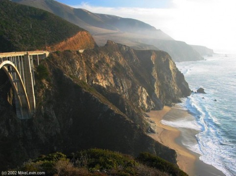
Tourism Bixby Bridge, shown here looking southwest, is a popular attraction in Big Sur Although some Big Sur residents catered to adventurous travelers in the early twentieth century,[22] the modern tourist economy began when Highway 1 opened the region to automobiles, and only took off after World War II-era gasoline rationing ended in the mid-1940s. Most of the 3 million tourists who visit Big Sur each year never leave Highway 1, because the adjacent Santa Lucia mountain range is one of the largest roadless areas near a coast in the lower 48 states. The highway winds along the western flank of the mountains mostly within sight of the Pacific Ocean, varying from near sea level up to a thousand-foot sheer drop to the water. Because gazing at the views while driving is inadvisable, the highway features many strategically placed vista points allowing motorists to stop and admire the landscape. The section of Highway 1 running through Big Sur is widely considered as one of the most scenic driving routes in the United States, if not the world. These breathtaking views were one reason that Big Sur ranked second among all United States destinations in TripAdvisor's 2008 Travelers' Choice Destination Awards.[23]
The land use restrictions that preserve Big Sur's natural beauty also mean that tourist accommodations are limited, often expensive, and fill up quickly during the busy summer season. There are fewer than 300 hotel rooms on the entire 90 mile (140 km) stretch of Highway 1 between San Simeon and Carmel, only three gas stations, and no chain hotels, supermarkets, or fast-food outlets.[24] The lodging options are rustic cabins, motels, and campgrounds, or costly, exclusive five-star resorts, with little in between. Most lodging and restaurants are clustered in the Big Sur River valley, where Highway 1 leaves the coast for a few miles and winds into a redwood forest, protected from the chill ocean breezes and summer fog.
Besides sightseeing from the highway, Big Sur offers hiking, mountain climbing, and other outdoor activities. There are a few small, scenic beaches that are popular for walking, but usually unsuitable for swimming because of unpredictable currents and frigid temperatures. Big Sur's nine state parks have many points of interest, including one of the few waterfalls on the Pacific Coast that plunges directly into the ocean, located at Julia Pfeiffer Burns State Park, although visitors are not allowed on the beach itself to preserve the natural habitat. The waterfall is located near the ruins of a grand stone cliffside house that was the region's first electrified dwelling. Another notable landmark is the only complete nineteenth century lighthouse complex open to the public in California, set on a lonely, windswept hill that looks like an island in the fog.
Point Reyes National Seashore
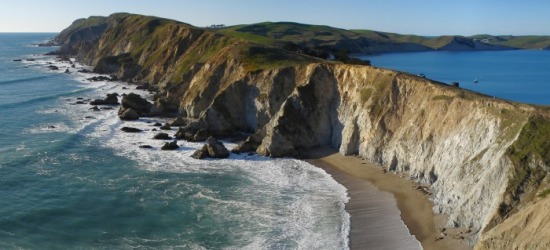
Point Reyes National Seashore is 70,000 acre (283 km²) park preserve located on the Point Reyes Peninsula in Marin County, California, USA. As a national seashore, it is maintained by the US National Park Service as a nationally important nature preserve within which existing agricultural uses are allowed to continue. Clem Miller, a US Congressman from Marin County wrote and introduced the bill for the establishment of Point Reyes National Seashore in 1962 to protect the peninsula from residential development which was proposed at the time for the slopes above Drake's Bay. Miller's vision included the continuation of the historic ranching and oyster farming along with the preservation of the grasslands and open scenic vistas. The mix of commercial and recreational uses was the reason the area was designated a National Seashore rather than a National Park.Description The Point Reyes peninsula is a well defined area, geologically separated from the rest of Marin County and almost all of the continental United States by a rift zone of the San Andreas Fault[2], about half of which is sunk below sea level and forms Tomales Bay. The fact that the peninsula is on a different tectonic plate than the east shore of Tomales Bay produces a difference in soils and therefore to some extent a noticeable difference in vegetation.
The small town of Point Reyes Station, although not actually located on the peninsula, nevertheless provides most services to it, though some services are also available at Inverness on the west shore of Tomales Bay. The even smaller town of Olema, about three miles south of Point Reyes Station, serves as the gateway to the Seashore and its visitor center, located on Bear Valley Road.
The peninsula includes wild coastal beaches and headlands, estuaries, and uplands, with a coastline that bears a striking resemblance to Cape Point, Cape of Good Hope, South Africa. Although parts of the Seashore are commercially farmed, and parts are under the jurisdiction of other conservation authorities, the National Park Service provides signage and seeks to manage visitor impact on the entire peninsula and virtually all of Tomales Bay. The Seashore also administers the parts of the Golden Gate National Recreation area, such as the Olema Valley, that are adjacent to the Seashore.
The northernmost part of the peninsula is maintained as a reserve for tule elk, which are readily seen there. The preserve is also very rich in raptors and shorebirds.[2]
The Point Reyes Lighthouse attracts whale-watchers looking for the Gray Whale migrating south in mid-January and north in mid-March.
The Point Reyes Lifeboat Station is a National Historic Landmark. It is the last remaining example of a rail launched lifeboat station that was common on the Pacific coast.
The Point Reyes National Seashore attracts 2.5 million visitors annually.
Hiking Bear Valley Trail is the most popular hike in the park. Taking off from the visitor's center, it travels mostly streamside through a shaded, fern-laden canyon, breaking out at Divide Meadow before heading gently downward to the coast, where it emerges at the spectacular ocean view at Arch Rock. Three trails connecting from the west with the Bear Valley trail head upward toward Mt. Wittenberg, at 1,407 feet (429 m), the highest point in the park.[2].
Across the parking lot at the Visitor's Center is the Earthquake Trail which is is a 0.6 mile loop that runs directly over the San Andreas Fault, deep underground. so that it is possible to stand straddling the fault line. The trail provides descriptions of the fault and the surrounding geology, and there is a fence that was pulled 18 feet apart during the 1906 San Francisco Earthquake.[1]
At the western end of the Point Reyes Peninsula is the historic Point Reyes Lighthouse, reached by descending 308 steps. Unlike many lighthouses, that were built high so the light could be seen by ships far out to sea, the Point Reyes lighthouse was built low to get the light below the fog that is so prominent in the area. Nearby is the short Chimney Rock hike, which is noted for its spring wildflower displays.[2]
As befitting a national seashore, Point Reyes offers several beach walks. Limantour Spit winds up on a narrow sandy beach, from which Drakes Beach can be glimpsed across Drakes Bay. North Beach and South Beach are often windswept and wave-pounded. Ocean vistas from higher ground can be seen from the Tomales Point Trail and, to the south, from the Palomarin trailhead at the park's southern entrance outside the town of Bolinas.
For backpackers, Point Reyes has four hike-in campgrounds available by reservation.
Alcatraz Island
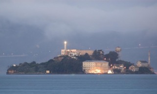
Alcatraz Island, sometimes informally referred to as simply Alcatraz or locally as the Rock, is a small island located in the middle of San Francisco Bay in California, United States. It served as a lighthouse, then a military fortification, then a military prison followed by a federal prison until 1963. It became a national recreation area in 1972 and received landmarking designations in 1976 and 1986.
Today, the island is a historic site operated by the National Park Service as part of the Golden Gate National Recreation Area and is open to tours. Visitors can reach the island by ferry ride from Pier 33, near Fisherman's Wharf in San Francisco.
San Luis Obispo and Morro Bay
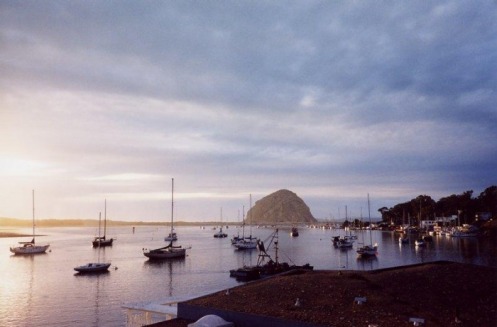
Morro Rock Morro Rock Main article: Morro Rock The town's most striking feature is Morro Rock, a 176 m high volcanic plug. Morro Rock stands at the entrance to the harbor, and a causeway connects it with the shore. Previously, it was surrounded by water, but the northern channel was filled in to make the harbor. The Rock, as locals call it, was quarried from 1889 to 1969. There is no public access to the rock itself because it is a reserve for the locally endangered peregrine falcon. However, the area around the base of Morro Rock can be visited. Every few years, someone is caught trying to climb the rock. Climbers risk more than fines or jail time as the rocks that form Morro Rock are loose and fall down regularly. The base of Morro Rock is littered with fallen boulders.
Morro Rock is one in a series of similar plugs that stretch in a line inland called the Nine Sisters. It is possible that the landscape moved over a volcanic hot spot through the ages.
[edit] Morro Bay Harbor The Morro Bay docks with Morro Rock in the background. Morro Bay is a natural embayment with an artificial harbor constructed by the U.S. Army Corps of Engineers. It is the only all-weather small craft commercial and recreational harbor between Santa Barbara and Monterey. Morro Rock was originally surrounded by water, but the Army built a large artificial breakwater and road across the north end of the harbor, linking Morro Rock and the mainland. Some of the rock used for this and for the artificial breakwaters was quarried from Morro Rock itself. Other rock was imported by barge from Catalina Island. The bay extends inland and parallels the shore for a distance of about 6.4 km (4 miles) south of its entrance at Morro Rock.
Only relatively small craft are capable of passing the harbor channel. A large natural sandspit, augmented by breakwaters, protects the harbor from the Pacific Ocean to the west. At its northern end, remains of a bridge that used to connect the shore with the sandspit can be seen. Morro Bay Harbor's channel silts up and must be dredged every three to four years. Previously, the Shark Inlet connected the back bay to the ocean. Some have proposed reopening it to slow the sedimentation that is filling up the bay. There has also been work on reducing erosion in the Chorro Creek watershed to reduce the amount of sediment coming into the bay to form bottom layers of bay mud. Chorro Creek is the bay's largest tributary. It forms an estuary in the back bay between Morro Bay and Los Osos. The second largest tributary, and the only other significant one, is Los Osos Creek, which empties into the far south end of the back bay.
Mariners are strongly urged to seek local advice prior to making use of the channel, especially when whitecaps or wind-blown water is evident or a small craft advisory is in effect, which is very often. The United States Coast Guard regards the harbor as one of the most dangerous in the entire nation, while others put it in the top six on the West Coast of the United States. In 1995, the Army Corps of Engineering deepened and expanded the channel to improve safety. From 1979 to 1987, 21 lives were lost in boating accidents alone. However, many additional deaths have resulted from sightseers and fisherman being swept off the rocks of the breakwater surrounding Morro Rock. They often approach too closely to the waves and are caught off guard when a big wave set comes in. The slippery and jagged rocks only add to the danger. Public access to the breakwater has been revoked and those who venture beyond the signs do so at their own peril.
Coast Guard Station Morro Bay operates two small vessels. Limited transient vessel services are available. Yachtsmen may wish to contact the Morro Bay Yacht Club. A public boat launch ramp is available at the far south end of the Embarcadero.
The back bay, roughly anything south of the Morro Bay State Park Marina, is very shallow. However, there is some slightly deeper water in the channels. The largest channel continues from the bay's main channel, winding its way towards Los Osos, on the southern end of the bay. The second largest breaks off from the largest about halfway to Los Osos and takes an extremely windy route to the sandspit. A few small channels on the landward side formed by runoff meet the largest channel as well. The narrow, unmarked channels are very hard to navigate and are filled with eel grass, which can snag the boat or clog the propeller. They are easiest to find at low tide, but if the tide is too low, the boat may run aground because the channels are only a few feet deeper than the surrounding water. An alternative to searching for the channels is to cross at very high tide.
During World War II, there was a U.S. Navy base on the north side of Morro Rock where sailors were trained to operate LCVPs. The breakwater on the southwest side of the Rock was built in 1944-45 to protect the LCVPs entering and leaving the harbor. Soldiers from Camp San Luis Obispo would come to Morro Bay and practice loading into the LCVPs. Many of those men were at Normandy on D-Day.
Sonoma County
Sonoma County, located on the northern coast of California, is one of the northernmost counties of the nine county Greater San Francisco Bay Area, U.S. Its population at the 2000 census was 458,614. Its largest city and county seat is Santa Rosa.
Sonoma County's Dry Creek Valley Sonoma is the southwestern county of California's Wine Country region, which also includes Napa, Mendocino, and Lake counties. It has thirteen approved American Viticultural Areas and over 250 wineries. In 2002 Sonoma County ranked as the thirty-second county in the United States in agricultural production.[1] As early as 1920 Sonoma County was ranked as the eighth most agriculturally productive U.S county and a leading producer of poultry products, hops, grapes, prunes, apples, and dairy products,[2] largely due to the abundance of high quality irrigation water. More than 7.4 million visitors each year, spending more than $1 billion in 2006. Sonoma County is the home of Sonoma State University and Santa Rosa Junior College.
Sonoma County was once home to several Native American tribes, who lived within the carrying capacity of the land; by 1850, European settlement had set a new direction that would prove to radically alter the course of land use and resource management of this region. As of 2007, Sonoma County has rich agricultural land, albeit now largely divided between two nearly monocultural uses: grapes and pasturage. The voters have twice approved open space initiatives[3] that have provided funding for public acquisition of natural areas, preserving forested areas, coastal habitat, and other open space.
Major highways U.S. Route 101
U.S. Route 101 is the westernmost Federal highway in the U.S.A. Running north/south through the states of California, Oregon, and Washington, it generally parallels the coastline from the Mexican border to the Canadian border. Highway 101 links seven of the county's nine incorporated cities: Cloverdale, Healdsburg, Windsor, Santa Rosa, Rohnert Park, Cotati, and Petaluma. It is a freeway for almost its entire length within the county, except for the section south of Petaluma.
The four-lane highway has been heavily congested during peak commute hours for many years. The section between Santa Rosa and Rohnert Park was recently widened to six lanes; and widening within Santa Rosa, between Highway 12 and Steele Lane, is nearing completion in 2008. The two new inner lanes are designated for vehicles with two or more occupants during commute hours.
State Route 1
Within Sonoma County, Highway 1 follows the coastline from the Mendocino County border, at the mouth of the Gualala River, to the Marin County border, at the Estero Americano (Americano Creek), east of Bodega Bay.
State Route 12
Highway 12 runs eastward from its intersection with Highway 116 in Sebastopol to Santa Rosa. There it turns south through the Valley of the Moon to Sonoma, then east into Napa County. The four-lane freeway section within Santa Rosa, between Fulton Road and Farmers Lane, is called the Luther Burbank Memorial Highway. That section, especially where it crosses Highway 101, is severely congested during peak commute hours.
The two-lane Bodega Highway runs west from the intersection of Highways 12 and 116 in Sebastopol, through the coastal hills to its intersection with Highway 1, east of Bodega Bay. East of Santa Rosa, Highway 12 is also called Sonoma Highway; and east of Sonoma, Carneros Highway.
State Route 37
Highway 37 connects Highway 101 at Novato, in Marin County, with Interstate 80 in Vallejo, in Solano County, at the top of San Pablo Bay. Within Sonoma County, it is also called Sears Point Road.
State Route 116
Highway 116 is a winding, two-lane rural route that runs from Jenner, at the mouth of the Russian River on the coast, southeast to Arnold Drive near Sonoma. It is also called Guerneville Highway, between Guerneville and Forestville; Gravenstein Highway North, between Forestville and Sebastopol; and Gravenstein Highway South, between Sebastopol and Stony Point Road, west of Rohnert Park. East of Petaluma it is Lakeville Highway, then Stage Gulch Road.
State Route 128
The northernmost section of Highway 128 is a two-lane rural route running southeast from Highway 101 at Geyserville, north of Healdsburg, through the Alexander Valley into Napa County.
Colorado
The Broadmoor
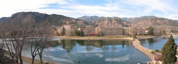
The Broadmoor Hotel[1] is a 5-star[2]/5-diamond luxury hotel and resort, located in southwestern Colorado Springs, Colorado[3]. Built in the early 20th century as the "Grand Dame of the Rockies", it was one of the finest resort destinations along the Rocky Mountains during the age of railroads[4]. It continues to be a popular conference destination for businessmen and government officials[5].It also offers a tennis facility rated #3 by Tennis Magazine.[6] and three 18-hole golf courses; the East Course has hosted numerous USGA championships, most recently the 2008 U.S. Senior Open[7]. The hotel sits at an elevation of 6230 feet (1900 m) above sea level. [1]
