Day One
Gettysburg PA
Sleep
State: Pennsylvania
Nearest City: Harrisburg
Nearest Town: Gettysburg
Cost: Free
Number of Campsites: 11-29
Max days allowed: 4
Road: Paved
Miles from paved road: Unknown
Scenery Rating: 4 out of 5
Noise Level: 1 out of 5
Amenities: Water, Electric, Sewer, Restrooms
Status: Official Months Open: Year Round
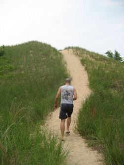
Description Amazing location on southern edge of the historic Gettysburg Battlefield. Huge pool, air-conditioned restroom facilities, country store, lake, easy access and easy to find. Free spots limited but easy to reserve in advance.
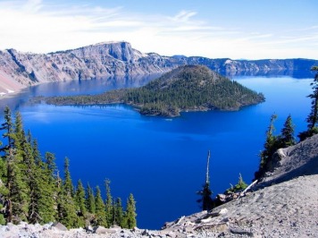
Gettysburg National Military Park
The Civil War's bloodiest battle with 51,000 casualties over three days in the summer of 1863 and the backdrop for President Abraham Lincoln's famous Gettysburg Address, the Gettysburg National Military Park features the Eternal Light Peace Memorial, Gettysburg National Military Park Visitor Center, McMillan Woods Youth Campground, a self-guided auto tour, licensed guide tour, tape or CD tours, the Gettysburg Museum of the Civil War, and more.
Travel to North to Sandusky OH
Day Two
Day Three
Cedar Point, Sandusky OH
Cedar Point is one of the oldest continuously operating amusement parks, having begun in the year 1870 as a beach resort on the shore of Lake Erie. Today it covers 364-acres and is home to more than 68 rides. It has the most roller coasters in a single amusement park, 17, with the opening of Maverick last summer. Although its primary attraction is the assortment of coasters, the park has rides and other attractions, including kiddie rides, water rides, a traditional arcade, award-winning musical shows and a PEANUTS-themed ice-skating show, etc. The park also offers access to the lovely beach on Lake Erie -- something which has been attracting visitors since its inception.
Two separate attractions are part of Cedar Point but not included in the general admission. Soak City is an outdoor water park; Castaway Bay is an elaborate indoor waterpark. Challenge Park features four attractions: 'Ripcord,' 'Skyscraper,' 'Challenge Racing' go kart tracks, and 'Challenge Golf', a fantasy miniature golf course.
One can easily spend a full day at the main Cedar Point by itself. If you plan to take in all the attractions, you should buy the 2 day "ride and slide" pass and to spread your enjoyment of Soak City and Cedar Point over two days.
Camping in Indiana
Camping:
Goshen Old K-Mart
State: Indiana
Nearest City: Elkhart
Nearest Town: Goshen
Cost: Free
Number of Campsites: Unknown
Max days allowed: Unknown
Road: Paved
Miles from paved road: Unknown
Scenery Rating: 3 out of 5
Noise Level: 1 out of 5
Amenities: None
Status: Unoffical
Months Open: Year Round
Description This boondocking area is located just off the US-20 bypass and headed towards Goshen on US-33. Three blocks from bypass on right side of road, there is a large paved parking lot behind Taco Bell. Nearby fast food chains; also a mall all located within walking distance. Elkhart County is the RV capital. Quiet and secure area. Many factories and dealers in the surrounding area.
Hoosier NF (German Ridge Camp) South
State: Indiana
Nearest City: Tell City
Nearest Town: Rome
Cost: $10 or less
Number of Campsites: 30 or more
Max days allowed: 14
Road: Unknown
Miles from paved road: Unknown
Scenery Rating: 4 out of 5
Noise Level: 1 out of 5
Amenities: Water, Restrooms
Status: Unknown
Months Open: Year Round Description Located near the Ohio River in Hoosier National Forest. There are two camping areas. The first is a formal camping area for RVs and tents, and is for non-electric primitive camping. The second is n a small lake with beach and beach house, and is for tent camping near the small lake. Both sites had free firewood at each site when I visited. Their are hiking trails, fishing and swimming.
Pigon River Fish & Wildlife Area (Northeast)
State: Indiana
Nearest City: Auburn
Nearest Town: Mongo
Cost: $10 or less
Number of Campsites: 30 or more
Max days allowed: 14
Road: Unknown
Miles from paved road: Unknown
Scenery Rating: 5 out of 5
Noise Level: 1 out of 5
Amenities: None
Status: Official
Months Open: Unknown
Description This is a beautiful river area with many lakes. It has a primitive campground with 44 sites. Fishing and motor boating or canoeing would fit the area.
Dunewood Campground
Dunewood Campground Phone 219-926-7561 x225
Season
Camping opens for 2007 season on Friday, March 30, 2007
Regular season dates are April 1 through October 31
A family starts a campfire inside one of the provided grates. Facilities 78 campsites: 53 conventional drive-in sites; 25 walk-in sites
Restrooms and showers
No electric hookups
Accessible to visitors with mobility impairments
No limit on recreational vehicle length
Fees All sites are $15.00 per night. Fees are reduced 50% for holders of Senior Pass/Golden Age and Access Pass/Golden Access card holders. Reservations are not accepted.
Attractions/Services Lake Michigan is located 1.5 miles north of the campground. Several beaches are within easy driving distance. A gas station and convenience store is located ¼ mile north of the campground at the intersection of U.S. Highway 12 and Broadway. A South Shore Railroad station, with passenger service to Chicago and South Bend, is located on Broadway, ¼ mile north of the campground.
Day Four
Indiana Dunes National Lake Shore
The sounds of waves massaging the soft warm sand beaches of Lake Michigan, has it always been this way? What would the sands of time tell us if they could speak? Citizens holding signs, politicians giving speeches, industrialists demanding a decision, what was to become of this place? Would it be turned into an industrial complex with thousands of jobs and tax dollars for the surrounding communities? Could environmentalists convince congress to turn it into a national park? Politicians had a tough choice to make; a struggle ensued over who would control the southern shore of Lake Michigan. Joseph Bailly, Anders Kjellberg, Stephen Mather, Frank V. Dudley, Dorothy Buell, and others came to the southern shore of Lake Michigan and discovered what the Potawatomis knew long ago--the dunes are more than just sand and beaches. More than 1,400 vascular plants species are distributed about the 15,000 acres of dunes, marshes, woodlands, river, and bog.
Botanist Dr. Henry Chandler Cowles wrote, “The Indiana dunes are a common meeting ground of trees and wildflowers from all directions.” Today, the park is a common meeting ground for people from around the world who are discovering the many wonders of Indiana dunes. We certainly hope our website will inspire you to come and explore the dunes yourself.
Sears Tower Deck, Chicago IL
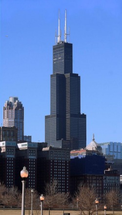
While no longer the world's tallest building, the Sears Tower still stands proud. High-speed elevators climb 110 stories to the observatory deck, and when clear, the view from 1,454 feet can be stunning. Enjoy bird's eye views of Lake Michigan, both the North and South Sides of the city, the surrounding suburbs and, on a clear day, parts of Indiana, Wisconsin and Michigan. The Skydeck Tour also includes a multimedia presentation and an exhibit with information on the Sears Tower and other architecturally significant buildings.
Camping
Paul Wolff Forest Preserve
State: Illinois
Nearest City: Chicago
Nearest Town: Elgin
Cost: $10 or less
Number of Campsites: 30 or more
Max days allowed: 14
Road: Paved
Miles from paved road: Unknown
Scenery Rating: 3 out of 5
Noise Level: 1 out of 5
Amenities: Water, Electric, Dump Station, Restrooms
Status: Official
Months Open: May through October
Description 1.5 miles west of Randal Road on Big Timber (south of I-90) on the south side of the road just after crossing the railroad tracks. Kane County Forest Preserve. Very nice, quiet grounds, well-kept; nice size sites, most with shade trees. Wooded primitive area on weekends.
Day Five
Travel to Badlands
This will take at least a day and the rest can be relaxation
Camping
24 Express
State: South Dakota
Nearest City: Rapid City
Nearest Town: Wasta
Cost: $10 or less
Number of Campsites: 10 or less
Max days allowed: Unknown
Road: Paved
Miles from paved road: Unknown
Scenery Rating: 5 out of 5
Noise Level: 1 out of 5
Amenities: Electric, Dump Station
Status: Official
Months Open: Year Round
Description On I-90 Exit 98. Self-contained RVs only. No sewer or water on sites. Gas station on property. Military Museum and gift shop under construction. Opening soon.
Elm Creek Campground
State: South Dakota
Nearest City: Mitchell
Nearest Town: Chamberlain
Cost: Free
Number of Campsites: 11-29
Max days allowed: 14
Road: Gravel Miles from paved road: 18.00
Scenery Rating: 3 out of 5
Noise Level: 1 out of 5
Amenities: Restrooms
Status: Unoffical
Months Open: May-October
Description Exit I-90 Route 265 18 miles south. Site previously administered by Corps of Engineers. Primitive sites located on the Missouri River. Toilets; NO DRINKING WATER. Pay campground adjacent.
Cedar Pass Campground
Located near the Ben Reifel Visitor Center, the Cedar Pass Campground has 96 level sites with scenic views of the badlands formations. Camping fees are $10 per night and can be paid at the automated fee machine, located at the campground's entrance. The fee machine will issue a camping permit. Cold running water, flush toilets, and covered picnic tables are available. A dump station is available for a $1.00 fee per use.
Day Six
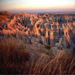
Badlands National Park
$15 Badlands
The park's main visitor center, the Ben Reifel Visitor Center, is open daily all year, except Thanksgiving, Christmas, and New Year's Day. During the summer months, ranger-led programs are offered throughout the day. Check at the visitor center for more information on these programs.
The Ben Reifel Visitor Center is located at Cedar Pass on the Badlands Loop Road (Hwy 240), 9 miles South of I-90, exit 131. This recently rehabilitated visitor center contains exhibits featuring geology, paleontology, park wildlife, and resource management. The 20-minute park movie, Land of Stone and Light, is shown throughout the day. Stop at the visitor center for information, restrooms, exhibits, and the park’s movie.
In the South Unit, the White River Visitor Center is open during the summer months and offers information, restrooms, and cultural exhibits.
The park is open all year. There are numerous pullouts and viewpoints along the park’s Loop Road where visitors can enjoy the scenery and native plants and wildlife of the mixed-grass prairie ecosystem.
Travel to Campground
Army Corps of Engineers Cottonwood Springs
State: South Dakota
Nearest City: Rapid City
Nearest Town: Hot Springs
Cost: $10 or less
Number of Campsites: 11-29
Max days allowed: 14
Road: Paved
Miles from paved road: Unknown
Scenery Rating: 5 out of 5
Noise Level: 1 out of 5
Amenities: Water, Restrooms
Status: Official
Months Open: Year Round
Description 5 miles west of Hot Springs on Star Route 18m 2 miles north on county road 17. Paved. Picnic shelters, 18 sites, restrooms and water, no electric. $5. Mid-September to mid-May is free with reduced amenities but I would check to be sure it is open in winter.
Army Corps of Engineers Cottonwood Springs
State: South Dakota
Nearest City: Rapid City
Nearest Town: Hot Springs
Cost: $10 or less
Number of Campsites: 11-29
Max days allowed: 14
Road: Paved
Miles from paved road: Unknown
Scenery Rating: 5 out of 5
Noise Level: 1 out of 5
Amenities: Water, Restrooms Status:
Official Months Open: Year Round
Description 5 miles west of Hot Springs on Star Route 18m 2 miles north on county road 17. Paved. Picnic shelters, 18 sites, restrooms and water, no electric. $5. Mid-September to mid-May is free with reduced amenities but I would check to be sure it is open in winter.
Day Seven
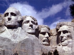
Mount Rushmore
The four figures carved in stone on Mount Rushmore represent the first 150 years of American history and the famous words of Gutzon Borgul, \"Until the wind and the rain alone shall wear them away,\" stand true today. The complex around this wonderful creation includes a parking structure, an amphitheater, a museum and theater complex, a visitor's center, a Presidential trail, dining facilities, a gift shop, and a book store. To complete your Rushmore experience, view the evening lighting ceremony.
Crazy Horse Memorial
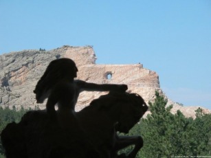
Crazy Horse Memorial, the world's largest sculpture, now in progress, is located just 17 miles southwest of Mount Rushmore. The Memorial includes the Indian Museum of North America, the Native American Cultural Center, the sculptor's studio, as well as a new 40,000 square foot Orientation Center and theaters. Many Native American artists and crafts people create their artwork and visit with guests at the Memorial during the summer season.
Camping in Wyoming
Bighorn Canyon National Recreation Area
State: Wyoming
Nearest City: Lovell
Nearest Town: Lovell
Cost: Free
Number of Campsites: 30 or more
Max days allowed: 14
Road: Paved
Miles from paved road: Unknown
Scenery Rating: 5 out of 5
Noise Level: 1 out of 5
Amenities: Water, Dump Station, Restrooms
Status: Official
Months Open: Year Round
Description Free campgrounds surrounding the lakes formed by the Yellowstone Dam in gorgeous canyon surroundings. This location is definitely worth routing towards. It's an official National Parks facility. There is a $5 park admission fee (self pay: the machine was broken when we arrived with a sign that said 'Enjoy!'). However, if you have a National Park pass, admission is included. There are entrances to the park (that don't connect to each other) in the south off Highway 37 via Lovell, WY or in the north near Fort Smith, Montana. We stayed at the Horseshoe Bend Campground off 37 14 miles north of Lovell, Wyoming. It had two big loops with 59 campspots, each with picnic tables and fire ring. Several had shade structures. There were also two comfort stations with flush toilets and sinks. Most sites seemed to only be able to accommodate smaller setups, so this might not be ideal for large motorhomes and trailers. There is a marina just down the road with a camp store, playground, boat launch and additional facilities. (Wasn't open when we were there in October). And the scenery was beyond stunning
Gillette Flying J
State: Wyoming
Nearest City: Gillette
Nearest Town: Gillette
Cost: Free
Number of Campsites: 30 or more
Max days allowed: Unknown
Road: Paved
Miles from paved road: Unknown
Scenery Rating: 2 out of 5
Noise Level: 4 out of 5
Amenities: Water, Dump Station, Restrooms
Status: Official
Months Open: Unknown
Description Smallest Flying J we have ever seen with some of the friendliest people. The RV island is off to the right as you enter adjacent to the LP tank but it does not have fuel at the island. No separate RV parking so you line up with the big rigs and put up with the engine noise
Homesteader Park-Powell
State: Wyoming
Nearest City: Cody
Nearest Town: Powell
Cost: Free
Number of Campsites: 11-29
Max days allowed: 2
Road: Paved
Miles from paved road: Unknown
Scenery Rating: None
Noise Level: 1 out of 5
Amenities: Water
Status: Official
Months Open: Unknown Description Just east of town on Highway 14A. There are two dozen plus sites. Two day limit. Not a bad little campground.
Lovell City Campground
State: Wyoming
Nearest City: Cody
Nearest Town: Lovell
Cost: Free
Number of Campsites: 10 or less
Max days allowed: 3
Road: Paved
Miles from paved road: Unknown
Scenery Rating: 5 out of 5
Noise Level: 1 out of 5
Amenities: Water, Dump Station, Restrooms
Status: Official
Months Open: Year Round
Description East 2nd Street off 14A and 310. Has a creek. Local deputy lives across the street. Very quiet. Red Apple grocery store 5 blocks away. You can weigh your vehicle for $1 at the grain mill. Liquor store behind Red Apple. On Main Street is a small cinema. UPS at Red Apple. Quaint midwest town with friendly atmosphere! Great stop before going into Big Horn Canyon.
Day Eight and Nine
Yellowstone National Park
If you are pinched for time and have only 1 or 2 days to tour Yellowstone, here's an itinerary that highlights the best of the best. If you'll be spending the night, your best bets are to reserve a room at either Old Faithful Inn or the Lake Yellowstone Hotel -- if those are booked, try the new Old Faithful Snow Lodge, or get a campsite at Norris or Indian Creek.
The quickest route to the inner road loops of the park is by the west entrance road, so come in that way, stopping perhaps for a stroll along the banks of the Madison River, where you can see the forest recovering from the 1988 fires. You'll also spot wildlife: ducks and trumpeter swans on the river, and grazing elk and bison. Turn north at Madison Junction to Norris Geyser Basin, where there are two boardwalk tours; take the southern one if you're in a hurry.
You're now driving the upper loop, which goes north to Mammoth Hot Springs, east to Tower-Roosevelt, south to Canyon Village, and west again to Norris, finally returning to Madison Junction, a circuit of about 85 miles (or 3 hr. of driving minimum). If you go south, rather than west, at Canyon Village, you'll be on the southern loop, which will take you to Fishing Bridge and Lake Village, then by West Thumb, west over Craig Pass to Old Faithful, and back to the Madison Junction. The entire lower loop covers 96 miles (another 3 hr. in the car, at the very least).
Altogether, this 2-day circuit is called the Grand Loop, taking you through all the major areas of the park except the road between Norris and Canyon Village. You could do it in a day -- it's less than 200 miles long -- but you'd scare a lot of other travelers as you sped by.
The Upper Loop
If you're pressed for time, the Norris Geyser Basin is a major concentration of thermal attractions, and also has a nice museum explaining the park's red-hot underpinnings. Mammoth has one of the park's major attractions, the ever-growing terraces of Mammoth Hot Springs. In addition to the natural attraction, the Albright Visitor Center provides excellent historical background for everything you see in the park. There is a fine old hotel at Mammoth and lodging just outside the park in Gardiner, too; but I recommend that you continue farther around the loop on your first day.
From Mammoth, the route winds through forested areas that lead to the edge of the Lamar Valley, a deep, rounded path for the Lamar River that is a prime haven for wolves, bison, elk, and grizzly bears. Otherwise, you can continue south to Yellowstone's Grand Canyon, one of the most dramatic sights in the park.
The Lower Loop
This is the better way to go if you have only a day. You'll also see the two largest geyser areas in Yellowstone -- Norris, to the north, and the park's signature attraction, Old Faithful, to the south. On the eastern side of this route, you'll find the Grand Canyon of the Yellowstone and Hayden Valley, where you'll often find a grazing herd of buffalo. Farther south, the Yellowstone Lake offers fishing, boating, and places for picnicking on the shore.
Landmarks
Avalanche Peak
Rate It
* Address: 2 mi east of Sylvan Lake on north side of East Entrance Rd., Fishing Bridge, Yellowstone National Park, WY | Map It
* Category: Trails
* Location: Fishing Bridge
Fodor's Review:
On a busy day in summer, maybe six parties will fill out the trail register at the Avalanche Peak trailhead, so you won't have a lot of company on this hike. Yet many say it's one of the best-kept secrets in the park. Starting across from a parking area on the East Entrance Road, the difficult 4-mi, 4-hour round-trip climbs 2,150 feet to the peak's 10,566-foot summit, from which you'll see the rugged Absaroka Mountains running north and south. Some of these peaks have patches of snow year-round. Look around the talus and tundra near the top of Avalanche Peak for alpine wildflowers and butterflies. Don't try this trail before late June or after early September -- it may be covered in deep snow. Also, rangers discourage hikers from attempting this hike in September or October because of bear activity. Whenever you decide to go, carry a jacket: the winds at the top are strong.
Mammoth Hot Springs Terraces
Rate It
* Address: Northwest corner of Grand Loop Rd., Mammoth Hot Springs, Yellowstone National Park, WY | Map It
* Category: Geological Sites
* Location: Mammoth Hot Springs
Fodor's Review:
Multicolor travertine terraces formed by slowly escaping hot mineral water mark this unusual geological formation. It constantly changes as a result of shifts in water flow. You can explore the terraces via an elaborate network of boardwalks. The best is the Lower Terrace Interpretive Trail. If you start at Liberty Cap, at the area's north end, and head uphill on the boardwalks, you'll pass bright and ornately terraced Minerva Spring. It's about an hour walk. Along the way you may spy elk, as they graze nearby. Alternatively, you can drive up to the Lower Terrace Overlook on Upper Terrace Drive and take the boardwalks down past New Blue Springs to the Lower Terrace. This route, which also take an hour, works especially well if you can park a second vehicle at the foot of Lower Terrace.
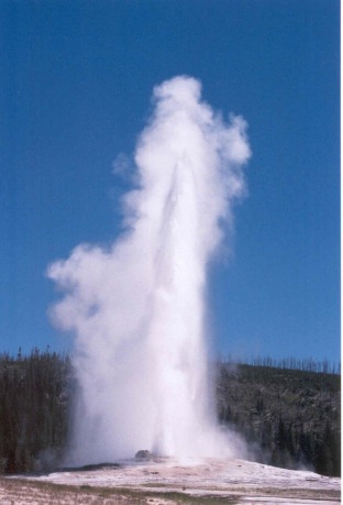
Old Faithful
Rate It
* Address: Southwest segment, Grand Loop Rd., Old Faithful, Yellowstone National Park, WY | Map It
* Category: Geological Sites
* Location: Old Faithful
Fodor's Review:
Almost every visitor includes the world's most famous geyser on his or her itinerary. Yellowstone's most predictable big geyser -- although not its largest or most regular -- sometimes reaches 180 feet, but it averages 130 feet. Sometimes it doesn't shoot as high, but in those cases the eruptions usually last longer. The mysterious plumbing of Yellowstone has lengthened Old Faithful's cycle somewhat in recent years, to every 94 minutes or so. To find out when Old Faithful is likely to erupt, check at the visitor center or at any of the lodging properties in the area. You can view the eruption from a bench just yards away, from the dining room at the lodge cafeteria, or from a guest room at the spectacular Old Faithful Inn (assuming you are lucky enough to spend the night there). The 1-mi hike to Observation Point yields yet another view -- from above -- of the geyser and its surrounding basin.
Yellowstone Lake
Rate It
* Address: Intersection of East Entrance Rd. and Grand Loop Rd., between Fishing Bridge and Grant Village, Yellowstone National Park, WY | Map It
* Category: Bodies of Water
* Location: West Yellowstone
Fodor's Review:
One of the world's largest alpine lakes, encompassing 132 square mi, Yellowstone Lake was formed when glaciers that once covered the region melted into a caldera -- a crater formed by a volcano. The lake has 141 mi of shoreline, less than one-third of it followed by the East Entrance Road and Grand Loop Road, along which you will often see moose, elk, waterfowl, and other wildlife. In winter you can sometimes see otters and coyotes stepping gingerly on the ice at the lake's edge. Many visitors head here for the excellent fishing -- streams flowing into the lake give it an abundant supply of trout.
Northeast Entrance Road and Lamar Valley
Rate It
* Address: From Northeast Entrance near Cooke City to junction with Grand Loop Rd. at Roosevelt Lodge, Tower-Roosevelt, Yellowstone National Park, WY | Map It
* Category: Scenic Drives
* Location: Tower-Roosevelt
Fodor's Review:
The 29-mi road features the richest diversity of landscape of the five entrance roads. Just after you enter the park from the northeast, you'll cut between 10,928-foot Abiathar Peak and the 10,404-foot Barronette Peak. You'll pass the extinct geothermal cone called Soda Butte as well as the two nicest campgrounds in the park, Pebble Creek and Slough Creek. Lamar Valley is the home to hundreds of bison, and the rugged peaks and ridges adjacent to it are home to some of the park's most famous wolf packs (reintroduced in 1995). The main wolf-watching activities in the park occur here during early-morning and late-evening hours year-round. As you exit Lamar Valley, the road crosses the Yellowstone River before leading you to the rustic Roosevelt Lodge.
Mammoth
Mammoth Hot Springs Mammoth Hot Springs are the main attraction of the Mammoth District. These features are quite different from thermal areas elsewhere in the park. Travertine formations grow much more rapidly than sinter formations due to the softer nature of limestone. As hot water rises through limestone, large quantities of rock are dissolved by the hot water, and a white chalky mineral is deposited on the surface. Although visitors are sometimes confused by the rapidly shifting activity of the hot springs and disappointed when a favorite spring appears to have "died," it is important to realize that the location of springs and the rate of flow changes daily, that "on-again-off-again" is the rule, and that the overall volume of water discharged by all of the springs fluctuates little. The Gardner River and Gardner River Canyon The North Entrance Road from Gardiner, Montana, to Mammoth Hot Springs, Wyoming, runs along the Gardner River. The road winds into the park, up the canyon, past crumbling walls of sandstone and ancient mudflows. The vegetation is much thicker in the canyon than on the open prairie down below, the common trees being Rocky Mountain juniper, cottonwood, and Douglas-fir. Low-growing willows also crowd the river's edge in the flatter, flood-prone sections of the canyon. Watch for wildlife in season: eagles, osprey, dippers, and kingfishers along the river and bighorn sheep in the steeper parts of the canyon. 45th Parallel Bridge and Boiling River A sign near where the road crosses the Gardner River marks the 45th parallel of latitude. The 45th parallel is an imaginary line that circles the globe halfway between the equator and the North Pole. This same line passes through Minneapolis-St. Paul, Ottawa, Bordeaux, Venice, Belgrade, and the northern tip of the Japanese islands. It is, here in Yellowstone, roughly aligned with the Montana-Wyoming border. A parking area on the east side of the road is used by bathers in the "Boiling River." Bathers must walk upstream about a half mile from the parking area to the place where the footpath reaches the river. This spot is also marked by large clouds of steam, especially in cold weather. Here, a large hot spring, known as Boiling River, enters the Gardner River. The hot and the cold water mix in pools along the river's edge. Bathers are allowed in the river during daylight hours only. Bathing suits are required, and no alcoholic beverages are allowed. Boiling River is closed in the springtime due to hazardous high water and often does not reopen until mid-summer. The Yellowstone Park Foundation funded the Boiling River Trail Project. They are a non-profit organization whose mission is to fund projects and programs that protect, preserve and enhance Yellowstone National Park. Mt. Everts Mt. Everts was named for explorer Truman Everts of the 1870 Washburn Expedition who became separated from his camping buddies, lost his glasses, lost his horse, and spent the next 37 days starving and freezing and hallucinating as he made his way through the untracked and inhospitable wilderness. Upon rescue, he was, according to his rescuers, within but a few hours of death. Everts never made it quite as far as Mt. Everts. He was found near the "Cut" on the Blacktail Plateau Drive and was mistaken for a black bear and nearly shot. His story, which he later published in Scribner's Monthly Magazine, remains one of Yellowstone's best known, lost-in-the-wilderness stories. It has also been published in book form, edited by Yellowstone's archivist Lee Whittlesey under the name Lost in the Yellowstone. Mt. Everts is made up of distinctly layered sandstones and shales--sedimentary rocks deposited when this area was covered by a shallow inland sea, 70 to 140 million years ago. Bunsen Peak Bunsen Peak and the "Bunsen burner" were both named for the German physicist, Robert Wilhelm Bunsen. Although most people are familiar with the "Bunsen burner," few people know why his students gave the burner that name. He was involved in pioneering research about geysers, and a "Bunsen burner" has a resemblance to a geyser. His theory on geysers was published in the 1800s, and it is still believed to be accurate. Bunsen Peak is 8,564 feet high (2,612 meters) and may be climbed via a trail that starts at the Golden Gate. Another trail, the old Bunsen Peak road, skirts around the flank of the peak from the YCC camp to the Golden Gate. This old road may be used by hikers, mountain-bikers, and skiers in winter. The peak is also interesting because it burned in the 1880s and then again in 1988. A series of old photos show the creep of trees up Bunsen following the 1880 fires, and the new patterns of open space created by the fires of 1988. Fort Yellowstone All of the red-roofed, many-chimneyed buildings in the Mammoth area are part of historic Fort Yellowstone. Beginning in 1886, after 14 years of poor civilian management of the park, the Cavalry was called upon to manage the park's resources and visitors. Because the Cavalry only expected to be here a short while, they built a temporary post near the base of the Terraces called Camp Sheridan. After five cold, harsh winters, they realized that their stay in the park was going to be longer than expected, so they built Fort Yellowstone, a permanent post. In 1891, the first building to be constructed was the guard house because it directly coincided with the Cavalry's mission--protection and management. There were three stages of construction at Fort Yellowstone. The first set of clapboard buildings were built in 1891, the second set in 1897 as the Fort expanded to a two-troop fort, and, finally, the stone buildings were built in 1909 making the fort's capacity 400 men or four troops. By 1916, the National Park Service was established, and the Cavalry gave control of Yellowstone back to the civilians. After a short time away, the Cavalry returned in 1917 and finished their duty completely in 1918. Since that time, historic Fort Yellowstone has been Yellowstone's headquarters. Roosevelt Arch The first major entrance for Yellowstone was at the north boundary. Before 1903, trains would bring visitors to Cinnabar, Montana, which was a few miles northwest of Gardiner, Montana, and people would climb onto horse-drawn coaches there to enter the park. In 1903, the railway finally came to Gardiner, and people entered through an enormous stone archway. Robert Reamer, a famous architect in Yellowstone, designed the immense stone arch for coaches to travel through on their way into the park. At the time of the arch's construction, President Theodore Roosevelt was visiting the park. He consequently placed the cornerstone for the arch, which then took his name. The top of the Roosevelt Arch is inscribed with "For the benefit and enjoyment of the people," which is from the Organic Act of 1916.
Norris
Norris Geyser Basin is the hottest, oldest, and most dynamic of Yellowstone's thermal areas. The highest temperature yet recorded in any geothermal area in Yellowstone was measured in a scientific drill hole at Norris: 459°F (237°C) just 1,087 feet (326 meters) below the surface! There are very few thermal features at Norris under the boiling point (199°F at this elevation). Norris shows evidence of having had thermal features for at least 115,000 years. The features in the basin change daily, with frequent disturbances from seismic activity and water fluctuations. The vast majority of the waters at Norris are acidic, including acid geysers which are very rare. Steamboat Geyser, the tallest geyser in the world (300 to 400 feet) and Echinus Geyser (pH 3.5 or so) are the most popular features. The basin consists of three areas: Porcelain Basin, Back Basin, and One Hundred Springs Plain. Porcelain Basin is barren of trees and provides a sensory experience in sound, color, and smell; a 3/4 mile dirt and boardwalk trail accesses this area. Back Basin is more heavily wooded with features scattered throughout the area; a 1.5 mile trail of boardwalk and dirt encircles this part of the basin. One Hundred Springs Plain is an off-trail section of the Norris Geyser Basin that is very acidic, hollow, and dangerous. Travel is discouraged without the guidance of knowledgeable staff members. The area was named after Philetus W. Norris, the second superintendent of Yellowstone, who provided the first detailed information about the thermal features. Roaring Mountain Located just north of Norris on the Norris-Mammoth section of the Grand Loop Road, Roaring Mountain is a large, acidic thermal area (solfatara) that contains many steam vents (fumaroles). In the late 1800s and early 1900s, the number, size, and power of the fumaroles was much greater than today. Gibbon River The Gibbon River flows from Wolf Lake through the Norris area and meets the Firehole River at Madison Junction to form the Madison River. Both cold and hot springs are responsible for the majority of the Gibbon's flow. Brook trout, brown trout, grayling, and rainbow trout find the Gibbon to their liking. The Gibbon River is fly-fishing only below Gibbon Falls. Virginia Cascades A three-mile section of the old road takes visitors past 60-foot high Virginia Cascades. This cascading waterfall is formed by the very small (at that point) Gibbon River.
Madison
Gibbon Falls This 84-foot (26-meter) waterfall tumbles over remnants of the Yellowstone Caldera rim. The rock wall on the opposite side of the road from the waterfall is the inner rim of the caldera. Monument Geyser Basin This small, nearly dormant basin lies at the top of a very steep one-mile trail. Thermos-bottle shaped geyser cones are remnants of a much more active time. Madison River The Madison River is formed at the junction of the Gibbon and Firehole rivers, hence Madison Junction. The Madison joins the Jefferson and the Gallatin rivers at Three Forks, Montana, to form the Missouri River. The Madison is a blue-ribbon fly fishing stream with healthy stocks of brown and rainbow trout and mountain whitefish. Terrace Springs The small thermal area just north of Madison Junction. This area provides the visitor with a short boardwalk tour of hot springs. Firehole River The Firehole River starts south of Old Faithful, runs through the thermal areas northward to join the Gibbon and form the Madison River. The Firehole is world famous among anglers for its pristine beauty and healthy brown, brook, and rainbow trout.
Old Faithful Area
The Upper Geyser Basin Yellowstone, as a whole, possesses close to 60 percent of the world's geysers. The Upper Geyser Basin is home to the largest numbers of this fragile feature found in the park. Within one square mile there are at least 150 of these hydrothermal wonders. Of this remarkable number, only five major geysers are predicted regularly by the naturalist staff. They are Castle, Grand, Daisy, Riverside, and Old Faithful. There are many frequent, smaller geysers to be seen and marveled at in this basin as well as numerous hot springs and one recently developed mudpot (if it lasts). Lower Geyser Basin This large area of hydrothermal activity can be viewed by foot along the boardwalk trail at Fountain Paint Pots and by car along the three mile Firehole Lake Drive. The latter is a one-way drive where you will find the sixth geyser predicted by the Old Faithful staff: Great Fountain. Its splashy eruptions send jets of diamond droplets bursting 100-200 feet in the air, while waves of water cascade down the raised terraces. Patience is a virtue with this twice-a-day geyser, as the predictions allow a 2 hour +/- window of opportunity. Fountain Flats Drive departs the Grand Loop Road just south of the Nez Perce picnic area and follows along the Firehole River to a trailhead 1.5 miles distant. From there, the Fountain Freight Road hiking/biking trail continues along the old roadbed giving hikers access to the Sentinel Meadows Trail and the Fairy Falls Trail. Also along this path is the only handicapped-accessible backcountry site in the Old Faithful district at Goose Lake. Midway Geyser Basin This geyser basin, though small in size compared to its companions along the Firehole River, holds large wonders for the visitor. Excelsior Geyser reveals a gaping crater 200 x 300 feet with a constant discharge of more than 4,000 gallons of water per minute into the Firehole River. Also in this surprising basin is Yellowstone's largest hot springs, Grand Prismatic Spring. This feature is 370 feet in diameter and more than 121 feet in depth. Lone Star Geyser Basin This backcountry geyser basin is easily reached by a 5-mile roundtrip hike from the trailhead south of Old Faithful. Lone Star Geyser erupts about every three hours. There is a logbook, located in a cache near the geyser, for observations of geyser times and types of eruptions. Shoshone Geyser Basin Shoshone Geyser Basin is reached by a 17-mile roundtrip hike that crosses the Continental Divide at Grant's Pass. This basin has no boardwalks, and extreme caution should be exercised when travelling through it. Trails in the basin must be used. Remote thermal areas, such as this, should be approached with respect, knowledge, and care. Be sure to emphasize personal safety and resource protection when entering a backcountry basin. Firehole River The river derives its name from the steam (which they thought was smoke from fires) witnessed by early trappers to the area. Their term for a mountain valley was "hole," and the designation was born. The Firehole River boasts a world-famous reputation for challenging fly-fishing. Brown, rainbow, and brook trout give the angler a wary target in this stream. Continental Divide at Craig Pass Craig Pass/Isa Lake Both names are used to describe the same location seven miles south of Old Faithful on the Grand Loop Road. At 8,262 feet along the Continental Divide, Isa Lake is a uniquely confusing feature. During spring runoff, it drains into both the Atlantic and Pacific Oceans at the same time! (And backwards, too!) The west side of the lake flows into the Firehole drainage and, eventually, the Atlantic throughout the year. The east side, during spring, flows toward the Snake River drainage and the Pacific. Waterfalls Kepler Cascades is the most easily reached waterfall in the district. A marked pullout just south of Old Faithful and a short walk from the car offers the visitor easy access to view this 125-foot cascade.
Lake Area
Yellowstone Lake With a surface area of 132 square miles, Yellowstone Lake is the largest lake at high elevation (i.e., more than 7,000 ft.) in North America. It is a natural lake, situated at 7,733 ft. above sea level. It is roughly 20 miles long and 14 miles wide with 141 miles of shoreline. It is frozen nearly half the year. It freezes in late December or early January and thaws in late May or early June. Recent research by Dr. Val Klump of the Center for Great Lakes Research and the University of Wisconsin has revolutionized the way we look at Yellowstone Lake. Figuratively, if one could pour all the water out of Yellowstone Lake, what would be found on the bottom is similar to what is found on land in Yellowstone; geysers, hot springs, and deep canyons. With a small submersible robot submarine, the researchers found a canyon just east of Stevenson Island which was 390 ft. deep. Prior to this finding, the deepest spot in the lake was thought to be 320 ft. at West Thumb. Underwater geysers, hot springs, and fumaroles were found at West Thumb and Mary and Sedge bays. The hottest spot in the lake was found at Mary Bay where the temperature was recorded at 252° F (122° C). Hollow pipes, or chimneys of silica, several feet in height, were found rising up from the lake bottom at Mary Bay. It is thought that these are the old plumbing systems of now dormant geysers. Rock spires up to 20-feet tall were found underwater near Bridge Bay. Samples of this rock are being analyzed, though it is believed that these features are probably related to underwater thermal activity. This group of researchers also found that the conditions in Yellowstone Lake are similar to those that occur near the famous hydrothermal vents on the Pacific Ocean's mid- ocean ridge. Nutrient- and mineral-rich submarine fountains support incredible plant and animal communities, including bacterial mats, sponges, and earthworms. Yellowstone River The Yellowstone River is the last major undammed river in the lower 48 states, flowing 671 miles from its source southeast of Yellowstone into the Missouri River and then, eventually, into the Atlantic Ocean. It begins in the Absaroka Mountain Range on Yount Peak. The river enters the park and meanders through the Thorofare region into Yellowstone Lake. It leaves the lake at Fishing Bridge and flows north over LeHardy Rapids and through Hayden Valley. After this peaceful stretch, it crashes over the Upper and Lower falls of the Grand Canyon. It then flows generally northwest, meeting it's largest tributary, the Lamar River, at Tower Junction. It continues through the Black Canyon and leaves the park near Gardiner, Montana. The Yellowstone River continues north and east through the state of Montana and joins the Missouri River near the eastern boundary line of the state. The Missouri River eventually joins the Mississippi River, which flows into the Atlantic Ocean at the Gulf of Mexico. In addition to the Yellowstone River, many of the spawning streams in the Lake/Fishing Bridge/Bridge Bay area provide critical food sources for grizzly bears in the spring time. Therefore, ecologically speaking, these river and streams are a primary resource in the district. The LeHardy Rapids are a cascade on the Yellowstone River, three miles north of Fishing Bridge. Geomorphologically, it is thought that this is the actual spot where the lake ends and the river continues it's northward flow. In the spring, many cutthroat trout may be seen here, resting in the shallow pools before expending bursts of energy to leap up the rapids on the their way to spawn under Fishing Bridge. The rapids were named for Paul LeHardy, a civilian topographer with the Jones Expedition in 1873. Jones and a partner started off on a raft with the intent of surveying the river, planning to meet the rest of their party at the Lower Falls. Upon hitting the rapids, the raft capsized, and many of the supplies were lost, including guns, bedding, and food. LeHardy and his partner saved what they could and continued their journey to the falls on foot. The rapids became a popular visitor attraction when a boardwalk was built in 1984 providing access to the area. Due to increased visitation, a group of harlequin ducks, which once frequented this area in spring, have not been seen for several years. The boardwalk has consequently been closed in early spring to protect this sensitive habitat, but the harlequins have not returned. Mud Volcano/Sulphur Caldron When the Washburn Expedition explored the area in 1870, Nathaniel Langford described Mud Volcano as "greatest marvel we have yet met with." Although the Mud Volcano can no longer be heard from a mile away nor does it throw mud from it's massive crater, the area is still eerily intriguing. The short loop from the parking lot past the Dragon's Mouth and the Mud Volcano is handicapped accessible. The half-mile upper loop trail via Sour Lake and the Black Dragon's Caldron is relatively steep. Two of the most popular features in the Mud Volcano front country are the Dragon's Mouth and the Black Dragon's Caldron. The rhythmic belching of steam and the flashing tongue of water give the Dragon's Mouth Spring it's name, though its activity has decreased notably since December 1994. The Black Dragon's Caldron exploded onto the landscape in 1948, blowing trees out by their roots and covering the surrounding forest with mud. The large roil in one end of the Caldron gives one the sense that the Black Dragon itself might rear it's head at any time. In January 1995, a new feature on the south bank of Mud Geyser became extremely active. It covers an area of 20 by 8 feet and is comprised of fumaroles, small pools, and frying-pan type features. Much of the hillside to the south and southwest of Mud Geyser is steaming and hissing with a few mudpots intermixed. This increase in activity precipitated a great deal of visitor interest and subsequent illegal entry into the area. The most dramatic features of the Mud Volcano area however, are not open to the public. The huge seething mud pot known as the "Gumper" is located off-boardwalk behind Sour Lake. The more recent features just south of the Gumper are some of the hottest and most active in the area. Ranger-guided walks are offered to provide visitors an opportunity to view this interesting place. Farther in the backcountry behind Mud Volcano, several features are being tested for the existence of thermophilic microbes, which may offer insights into origin of life theories as well as having medical/environmental applications. The Sulphur Caldron area can be viewed from a staging area just north of Mud Volcano. The Sulphur Caldron is among the most acidic springs in the park with a pH of 1.3. Its yellow, turbulent splashing waters bring to mind images of Shakespeare's soothsayers. Other features which can be viewed from this overlook are Turbulent Pool (which is no longer "turbulent") and the crater of a large, active mudpot. For more specific information on the features of the Mud Volcano/Sulphur Caldron area, consult the annual reports that are available in the Ranger Naturalist Office adjacent to the Fishing Bridge Visitor Center. Hayden and Pelican Valleys The Hayden Valley is located six miles north of Fishing Bridge Junction. The Pelican Valley is situated three miles east of Fishing Bridge. These two vast valleys comprise some of the best habitat in the lower 48 states for grizzly bears, bison, elk, and other wildlife species. Natural Bridge Located just south of Bridge Bay Campground, it is an easy one-mile walk to the Natural Bridge. There is also a bicycle trail leading to the bridge. The Natural Bridge was formed by erosion of this rhyolite outcrop by Bridge Creek. The top of the bridge is approximately 51 ft. above the creek. A short switchback trail leads to the top, though travel across the bridge is now prohibited to protect this feature.
Canyon Area
The Grand Canyon of the Yellowstone Be sure to take our online tour of the canyon. The Grand Canyon of the Yellowstone is the primary geologic feature in the Canyon District. It is roughly 20 miles long, measured from the Upper Falls to the Tower Fall area. Depth is 800 to 1,200 ft.; width is 1,500 to 4,000 ft. The canyon as we know it today is a very recent geologic feature. The present canyon is no more than 10,000 to 14,000 years old, although there has probably been a canyon in this location for a much longer period. The exact sequence of events in the formation of the canyon is not well understood, as there has been little field work done in the area. The few studies that are available are thought to be inaccurate. We do know that the canyon was formed by erosion rather than by glaciation. A more complete explanation can be found in the Geological Overview section. The geologic story of the canyon, its historical significance as a barrier to travel, its significance as destination/attraction, and its appearance in Native American lore and in the accounts of early explorers are all important interpretive points. The "ooh-ahh" factor is also important: its beauty and grandeur, its significance as a feature to be preserved, and the development of the national park idea. The Upper and Lower Falls of the Yellowstone See these falls on the online tour of the canyon. The falls are erosional features formed by the Yellowstone River as it flows over progressively softer, less resistant rock. The Upper Falls is upstream of the Lower Falls and is 109 ft. high. It can be seen from the Brink of the Upper Falls Trail and from Uncle Tom's Trail. The Lower Falls is 308 ft. high and can be seen from Lookout Point, Red Rock Point, Artist Point, Brink of the Lower Falls Trail, and from various points on the South Rim Trail. The Lower Falls is often described as being more than twice the size of Niagara, although this only refers to its height and not the volume of water flowing over it. The volume of water flowing over the falls can vary from 63,500 gal/sec at peak runoff to 5,000 gal/sec in the fall. A third falls can be found in the canyon between the Upper and Lower falls. Crystal Falls is the outfall of Cascade Creek into the canyon. It can be seen from the South Rim Trail just east of the Uncle Tom's area.
Teddy Roosevelt Area
Petrified Tree The Petrified Tree, located near the Lost Lake trailhead, is an excellent example of an ancient redwood, similar to many found on Specimen Ridge, that is easily accessible to park visitors. The interpretive message here also applies to those trees found on Specimen Ridge. Specimen Ridge Specimen Ridge, located along the Northeast Entrance Road east of Tower Junction, contains the largest concentration of petrified trees in the world. There are also excellent samples of petrified leaf impressions, conifer needles, and microscopic pollen from numerous species no longer growing in the park. Specimen Ridge provides a superb "window" into the distant past when plant communities and climatic conditions were much different than today. Tower Fall Tower Fall is the most recognizable natural feature in the district. The 132-foot drop of Tower Creek, framed by eroded volcanic pinnacles has been documented by park visitors from the earliest trips of Europeans into the Yellowstone region. Its idyllic setting has inspired numerous artists, including Thomas Moran. His painting of Tower Fall played a crucial role in the establishment of Yellowstone National Park in 1872. The nearby Bannock Ford on the Yellowstone River was an important travel route for early Native Americans as well as for early European visitors and miners up to the late 19th century.
Camping in Yellowstone
Norris at Yellowstone National Park State: Wyoming Nearest City: Yellowstone Park Nearest Town: Northwest Yellowstone Park Cost: $10 or less Number of Campsites: 30 or more Max days allowed: Unknown Road: Gravel Miles from paved road: Unknown Scenery Rating: 3 out of 5 Noise Level: 1 out of 5 Amenities: Restrooms Status: Official Months Open: Unknown Description $7 with Golden Age card. Rough, steep campsites. Most are pretty tight, but 2 are reserved for big rigs if you can get to them. Very tight roads, etc. Restrooms and potable water but no hookups. September 1, '05, there was a buffalo wandering within a couple feet of RVs and tents. The ranger told us that grizzlies frequently cut through the camp area, but did no harm. (I sure wouldn't want to be outside when one went through)!
West of Flagg Ranch, Wyoming State: Wyoming Nearest City: Jackson Hole Nearest Town: Between Grand Teton and Yellowstone Cost: Free Number of Campsites: 10 or less Max days allowed: Unknown Road: Gravel Miles from paved road: 1.00 Scenery Rating: 3 out of 5 Noise Level: 1 out of 5 Amenities: None Status: Unknown Months Open: Unknown Description 6 small designated camping areas with between 2 and 6 sites west of Flagg Ranch. Take the paved road north, then west of Flagg Ranch until it turns to gravel. The first campground is 1/2 mile on the well maintained gravel state highway. The last one is about 7 miles further down the road. The road will continue to Idaho, but I took my 30' class A all the way and don't recommend it.
Jackson Hole, Grand Teton National Park State: Wyoming Nearest City: Jackson Hole Nearest Town: Kelly Cost: Free Number of Campsites: 11-29 Max days allowed: 5 Road: Dirt Miles from paved road: 1.00 Scenery Rating: 5 out of 5 Noise Level: 1 out of 5 Amenities: None Status: Unoffical Months Open: Late June - Mid September Description Could be the most fantastic views in the world! Shadow Mountain (USFS land) lies along the eastern border of Grand Teton National Park. Off Highway 26/89 just north of the Park Visitor Center and Blacktail Butte, turn east on Antelope Flats Road. At the stop sign turn north to Shadow Mountain. The road becomes gravel. DO NOT travel this road in the spring (before Father's Day) or in wet times. At the base of the mountain is an informal Forest Service camp area which is usually busy and often not all that clean. There are other sites along the base to Antelope Springs to the north, but often the road is rough; but maybe not. Continue up the mountain and the first really fine site you’ll come to is a chalk white open area with fantastic views. You can continue to the top of the mountain where you’ll find lots of sites with incredible views of Jackson Hole and the Mt Leidy Highlands to the east. Forewarning: This is pure dry camping in grizzle bear country. Suggest you unhook and scout it out. Suggest you unhook and scout it out, but all that effort is worth it! It is a relatively steep, Wyoming, Forest Service, rough gravel road, which may not be graded out until the fall hunting season. Four-wheel drive is necessary in case it gets wet. I’d take a 30’ trailer up there in good weather without concern. The campsites are all informal; public made. It is no place to go until after July 1 and not after September 15. But there are no better views of the Earth’s most beautiful valley that is Jackson Hole, Wyoming. And it’s all free.
Day Ten
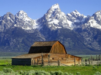
Grand Teton National Park
When you're back on dry ground, drive north on Teton Park Road, stopping at scenic turnouts -- don't miss Teton Glacier -- until you reach Jenny Lake Road, which is one-way headed south. After a brief stop at Cathedral Group Turnout, park at the Jenny Lake ranger station and take the 20-minute boat ride to Cascade Canyon trailhead for a short hike. Return to your car by midafternoon, drive back to Teton Park Road, and head north to Signal Mountain Road to catch a top-of-the-park view of the Tetons. In late afternoon descend the mountain and continue north on Teton Park Road. At Jackson Lake Junction, you can go east to Oxbow Bend or north to Willow Flats, both excellent spots for wildlife viewing before you head to Jackson Lake Lodge for dinner and an evening watching the sun set over the Tetons. Or if you'd like to get back on the water, drive to Colter Bay Marina, where you can board a 1 1/2-hour sunset cruise across Jackson Lake to Waterfalls Canyon. You can reverse this route if you're heading south from Yellowstone: start the day with a 7:30 AM breakfast cruise from Colter Bay and end it with a sunset float down the Snake River.
Scenic Drives
Antelope Flats Road. Off U.S. 191/89/26, about 2 mi north of Moose Junction, this narrow road wanders eastward over rolling plains, rising buttes, and sagebrush flats. The road intersects Mormon Row, where you can turn off to see abandoned homesteaders' barns and houses from the turn of the 20th century. Less than 2 mi past Mormon Row is a four-way intersection where you can turn right to loop around past the town of Kelly and Gros Ventre campground and rejoin U.S. 191/26/89 at Gros Ventre Junction. Keep an eye out for pronghorn, bison, moose, and mountain bikers.
Jackson Hole Highway (U.S. 191/26/89). Slicing through the middle of Jackson Hole, this busy highway passes views of the Teton Range along most of its distance, with a turnout at the Snake River Overlook and another picturesque Snake River view at Oxbow Bend.
Jenny Lake Scenic Drive. This 4-mi, one-way loop provides the park's best roadside close-ups of the Tetons as it winds south through groves of lodgepole-pine and open meadows. Roughly 1.5 mi off Teton Park Road, the Cathedral Group Turnout faces 13,770-foot Grand Teton (the range's highest peak), flanked by 12,928-foot Mt. Owen and 12,325-foot Mt. Teewinot. Jenny Lake.
Signal Mountain Road. This exciting drive climbs Signal Mountain's 1,040-foot prominence along a 5-mi stretch of switchbacks. As you travel through forest you can catch glimpses of Jackson Lake and Mt. Moran. The trip ends with a sweeping view -- from 7,720 feet above sea level -- of Jackson Hole and the entire 40-mi Teton Range. Sunset is the best time to make the climb up Signal Mountain. The road is not appropriate for long trailers and is closed in winter. Oxbow Bend.
Teton Park Road. Linking Moose Junction with Jackson Lake Junction, this 20-mi drive is the closest to the Teton Range and it ties in with the Jenny Lake Scenic Drive. The main road skirts Jackson Lake, with Signal Mountain looming to the east. Farther south, turnouts give you excellent views of Mt. Moran and the Cathedral Group (the three highest peaks in the Teton Range).Antelop
Visitor's Centers
RANGER STATIONS Jenny Lake Ranger Station Open Late May to September 23rd, call for hours Phone (307) 739-3343 Closures Closed in winter. Visitor Services Features in-depth information for visitors planning to climb and backpack in the park. VISITOR CENTERS Colter Bay Visitor Center & Indian Arts Museum Open May 12 to June 3: 8:00 a.m. - 5:00 p.m. June 4 to early September: 8:00 a.m. - 7:00 p.m. Early September to early October: 8:00 a.m. - 5:00 p.m. Phone (307) 739-3594 Location Located 25 miles north of Moose, adjacent to Jackson Lake. Closures Closes for season October 9, 2006. Special Programs From June through September craft demonstrations and museum tours are offered, as well as other interpretive programs. Exhibits The Indian Arts Museum displays some of the David T. Vernon Collection, an impressive variety of American Indian artifacts donated by the Rockefeller family. Visitor Services A large bookstore, information desk, auditorium, telephones, restrooms and backcountry permits. Flagg Ranch Information Station (2007) Open June 4 to September 3: 9:00 a.m. - 4:00 p.m., closed for lunch. Phone (307) 543-2327 Location Located about 2.5 miles south of Yellowstone National Park's south boundary and 40 miles north of Moose. Closures Closes for season Sept 4, 2007 Exhibits Features information about the John D. Rockefeller, Jr. Memorial Parkway and the Greater Yellowstone Area. Visitor Services Book sales, park information and restrooms. Jenny Lake Visitor Center (2007) Open May 13 to June 3: 8 a.m. to 4:30 p.m. June 4 to September 3: 8 a.m. to 7 p.m. September 4 to September 28: 8 a.m. to 4:30 p.m. Location Located 8 miles north of Moose at South Jenny Lake. Closures Closed October through May. Exhibits Features geology exhibits, information and a relief map of the park. Visitor Services Activity schedules, guided walks and talks, maps, bookstore, restrooms, store and telephones adjacent. Jenny Lake Campground is nearby. Craig Thomas Discovery & Visitor Center (2007) Open Open Year-round: 8:00 a.m. - 5:00 p.m. (closes at 7:00 p.m. during peak summer season: June 4 - Sept 3.) Phone (307) 739-3399 Location Located 12 miles north of Jackson. Closures December 25 Exhibits The Discovery Center features natural history exhibits, a relief map of the park, and an introductory video.
Day Eleven
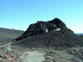
Craters on the Moon National Monument
The seven-mile loop road provides unequaled opportunities to explore Craters of the Moon; including access to trails that take you over, under, and around various volcanic features. Trail mileages are round-trip distances. Allow half an hour for the drive itself and more time for stopping at viewpoints and for hiking the trails.
North Crater Flow
A short trail (0.25 mile) crosses one of the youngest flows to monoliths-crater fragments rafted here by lava flows. A nearby longer trail (3.5 miles) windes through the vent of North Crater, past the Big Craters to the Spatter Cones parking lot.
Devil's Orchard
Island-like lava fragments stand in a sea of cinders. Take the spur road and short walk (0.5 mile, accessible) through these weird features. Learn about how human impacts on the park, and how the park is being protected today.
Inferno Cone
From atop this cone (a short, steep 0.5-mile walk) you see cinder cones lined up along the Great Rift. Big Cinder Butte, towering above the lava plain to the south, is one of world's largest basaltic cinder cones.
Spatter Cones
Take the short accessible trail to view these miniature volcanoes. You can also view the spectacular Big Craters by hiking a steep 0.5-mile portion of the North Crater trail that branches off to the west.
Caves
See lava tubes-Dewdrop, Boy Scout, Beauty, and Indian Tunnel-via a 0.5 mile trail across the lava. In all but Indian Tunnel you must carry a light source.
Travel to Oregon
Fun ride
Camping
Mazama Campground
Open mid-June to early October (weather permitting)
Mazama campground has 200 sites and is open mid-June through early October. Reservations are not taken, however sites are usually available. Running water, flush toilets, picnic tables, and fire rings are provided. Please Note - Weather can impact the opening and closing dates of the campground.
Chickhominy Reservoir Campground State: Oregon Nearest City: Burns Nearest Town: Riley Cost: $10 or less Number of Campsites: 11-29 Max days allowed: Unknown Road: Gravel Miles from paved road: 0.25 Scenery Rating: 3 out of 5 Noise Level: 1 out of 5 Amenities: Water, Restrooms Status: Official Months Open: April-September Description On US 20, 7 miles west of Riley between MM 99 and 100. ¼-mile paved road to BLM campground near a large reservoir noted for good fishing, but it may be dry in the summer. 28 designated campsites on good gravel roads with table, fire ring, vault toilets, and threaded water faucet at fish cleaning station. All designated campsites are pull-throughs and most can accommodate rigs up to 40’ plus a tow/towed vehicle. Dispersed camping can accommodate any size rig. The campground is exposed to the sun and wind, and can get very hot in the summer, but wind generally dies down in the early evening. Season is April-September; no reservations. $8/site whether designated or dispersed. Golden Age Passport accepted.
McKay Crossing Campground State: Oregon Nearest City: Bend Nearest Town: La Pine Cost: $10 or less Number of Campsites: 10 or less Max days allowed: 14 Road: Dirt Miles from paved road: 6.00 Scenery Rating: 3 out of 5 Noise Level: 2 out of 5 Amenities: None Status: Official Months Open: April-September Description Deschutes National Forest-Bend/Fort Rock Ranger District on Paulina Creek From Bend, 23.5 miles south on Highway 97, 3.2 miles east on Road 21, and then 2.7 miles east on F.S. Road 2120. NOTE: 6/13/05 The bridge in the campground across Paulina Creek has been condemned and will be removed later this year and is not likely to be replaced soon. Camp sites on the north side of the creek will be dismantled, the restroom facility will be closed, and camping there will not be permitted to prevent sanitation problems. 10 RV/trailer/tent sites maximum length 26'. Vault toilets and no drinking water ELEVATION: 4750 feet. Hiking, bird watching, bicycling, access to Peter Skeen Ogden Trail (#56) OPERATED BY: High Lakes Contractors FEE: $5 per vehicle per night per site
Valley of the Rogue State Park State: Oregon Nearest City: Grant's Pass Nearest Town: Rogue River Cost: $10 or less Number of Campsites: 30 or more Max days allowed: Unknown Road: Paved Miles from paved road: Unknown Scenery Rating: 5 out of 5 Noise Level: 2 out of 5 Amenities: Water, Electric, Sewer, Dump Station, Restrooms Status: Official Months Open: Unknown Description Beautiful state park right off I-5 about ten miles south of Grant's Pass. $16 for full hookups when we stayed here and very quiet despite being right off the interstate. We intended to overnight here but ended up staying a week. Not free but the best bargain we've found in nine months of RVing.
Day Twelve
Crater Lake
Fees
Car - $10.00 (7 day pass)
Steel Visitor Center
Hours of Operation: Open daily, except December 25th
November to April 10:00 AM-4:00 PM
May to October 9:00 AM-5:00 PM
Phone: (541)594-3100
Location: Park Headquarters
Special Programs: An 18-minute film, Crater Lake: The Mirror of Heaven, is shown every half hour.
Exhibits: Exhibits provide park orientation.
Available Facilities: Post Office at Steel Visitor Center open Monday through Saturday, 10:00 AM - 2:00 PM, except holidays.
Rim Visitor Center
Hours of Operation: June through September, 9:30 AM-5:00 PM
Phone: (541)594-3090
Location: Rim Village
Exhibits: Exhibits on geology and lake research are located in the nearby Sinnott Memorial Overlook, open July through September.
Crater Lake has inspired people for hundreds of years. No place else on earth combines a deep, pure lake, so blue in color; sheer surrounding cliffs, almost two thousand feet high; two picturesque islands; and a violent volcanic past. It is a place of immeasurable beauty, and an outstanding outdoor laboratory and classroom.
Crater Lake is located in Southern Oregon on the crest of the Cascade Mountain range, 100 miles (160 km) east of the Pacific Ocean. It lies inside a caldera, or volcanic basin, created when the 12,000 foot (3,660 meter) high Mount Mazama collapsed 7,700 years ago following a large eruption.
Generous amounts of winter snow, averaging 533 inches (1,354 cm) per year, supply the lake with water. There are no inlets or outlets to the lake. Crater Lake, at 1,943 feet (592 meters) deep, is the seventh deepest lake in the world and the deepest in the United States. Evaporation and seepage prevent the lake from becoming any deeper.
Redwood National and State Parks
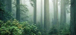
What lives in the redwood forest? Did you know that Redwood National and State Parks offers far more than just redwoods? Visit one of the five visitor centers to find out about ranger-led programs. Pick up an official map and look for these place names. Suggestions are given north to south.
* Discover Howland Hill Road and Stout Grove: a 10-mile scenic drive through old-growth redwoods, along Mill Creek, with a ½-mile walk through a river bottom grove of tremendous trees. Motorhomes and trailers not advised.
* Explore Enderts Beach and Crescent Beach Overlook: Stand before outstanding Pacific Ocean views from the overlook; you may even see a gray whale! Walk 1-mile to Enderts Beach, an access route to multi-colored, myriad tidepool creatures. Be sure to check low tide times. Trailers not advised
* Drive to Klamath River Overlook, a prime spot for watching the gray whale migration. Look for other marine mammals and a host of seabirds any time of year. Hike ¼ mile down a steep trail to the lower overlook and more dramatic views.
* Get off the beaten path and onto Coastal Drive! This 8-mile rough and tumble road winds past expansive Pacific Ocean views and descends into redwoods at Prairie Creek Redwoods State Park. Look through binoculars at the massive off shore rocks to spy thousands of seabirds nesting. Motorhomes and trailers prohibited on gravel section.
* Travel Newton B. Drury Scenic Parkway. Not even the Avenue of the Giants can beat this! A 10-mile scenic drive through ancient redwoods. Stop and walk an 1/8 of a mile to Big Tree Wayside; you'll see why! Watch for Roosevelt elk grazing in the prairie.
* Investigate Davison Road where Roosevelt elk hang out in the prairie. Trillium Falls Trail covers 2½ miles through ancestral forest and has one of the few falls in the parks. Follow Davison Road to the gray sands of Gold Bluffs Beach. See if you can find the remains of the mining era. Nothing compares to Fern Canyon with its 30-foot walls dripping wet and full of ferns. Survey the creek for slippery creatures. Trailers and vehicles longer than 24 feet prohibited.
* Be sure to stop at Kuchel Visitor Center one mile south of Orick. The state-of-the-art exhibits are fabulous!
Scenic Drives
If you’ve only got time for a quick drive or two at RNSP, check below for some exciting opportunities. Choose from a variety of lengths, road conditions, and environments to suit your tastes.
Howland Hill Road
NPS
Howland Hill Road.
Unpaved Scenic Roads
* Howland Hill Road (45 minutes one way). Discover the heart of the redwoods along this 6-mile (9½ km) improved gravel road in Jedediah Smith Redwoods State Park. A narrow and windy corridor, this route has numerous pullouts for you to stand beside an ancient one and offers many trailheads for exploration. Located at the northern end of the parks, Howland Hill Road is accessible from Highway 101 south of Crescent City by turning onto Elk Valley Road or from Highway 199, two miles east of the Hiouchi Information Center. Motorhomes and trailers not advised.
* Davison Road (30 minutes one way). This narrow 8-mile (13 km) road goes through a young redwood forest to the gray sands of Gold Bluffs Beach. Explore this isolated area: endless trailheads enter Prairie Creek Redwoods State Park, take a solar shower while staying at Gold Bluffs Beach campground, traverse the path and bridges along Fern Canyon with its 30-foot walls of ferns. Located on Highway 101 south from Crescent City 30 miles (48 km) or north two miles (3 km) from Orick. Vehicles and trailers with a combined length of more than 24 feet (7½ m) not permitted. State park day-use fee is charged.
* Cal-Barrel Road (30 minutes one way) Travel this 3-mile (5 km) road through old-growth forest in Prairie Creek Redwoods State Park. The narrow, winding road allows you time to look upon colossal redwoods. As pillars in the sky, see if your neck doesn't hurt! The turnoff is located north of the Prairie Creek Visitor Center on Newton B. Drury Scenic Parkway. Trailers or motorhomes prohibited.
* Bicycles are welcome on all roads.
Crescent Beach Overlook
NPS
Crescent Beach Overlook at the end of Enderts Beach Road.
Paved Scenic Drives
* Newton B. Drury Scenic Parkway (15-30 minutes one way). Ten-mile (16-km) drive through old-growth redwood forest in Prairie Creek Redwoods State Park. Along the way, look for access to numerous trailheads and spy the brawny Roosevelt elk. This scenic alternate to Highway 101 begins six miles north of Orick or four miles south of Klamath. No commercial vehicles permitted.
* Enderts Beach Road (5 minutes one way). This 2-mile (3-km) route offers excellent views of the ocean, whale watching opportunities, and access to tidepools and the Coastal Trail. The turnoff is two miles (3 km) south of Crescent City along Highway 101.
* Requa Road (15 minutes one way). Drive 4-miles (6-½ km) paved along the Klamath River up a steep grade to the Klamath River Overlook. Excellent whale and seabird watching. Bring your camera! Located two miles (3 km) north of the Klamath River on Highway 101.
High Bluff Overlook
NPS
High Bluff Overlook off Coastal Drive.
Paved/Unpaved Scenic Road
* Coastal Drive (1-2 hours one way). Mostly gravel 8-mile (13-km) road offers magnificent views of the ocean and the Klamath River with its estuary. Whales, sea lions, and pelicans are often seen from overlooks. Offers access to the Coastal Trail, Flint Ridge section. From the north, take Highway 101 to Klamath Beach Road, then follow the Coastal Drive signs. From the south, travel Highway 101 to the Newton B. Drury Scenic Parkway, then drive nine miles (14½ km) to the Coastal Drive turnoff. Trailers and motor homes prohibited.
Top of Page
Tall Trees Grove
NPS
Tall Trees Grove on Redwood Creek.
Tall Trees Grove:
* Permits to visit the Tall Trees Grove are available for no charge at the Thomas H. Kuchel Visitor Center, located on Highway 101, one mile (1½ km) south of Orick, at the Crescent City Information Center at 1111 Second Street, and at Prairie Creek Visitor Center on the Newton B. Drury Scenic Parkway. Visitors should plan to spend three to four hours for this hike. Limited to 50 cars per day.
Special events are offered throughout the year, call for dates and times, (707) 465-7306. These events may include:
* National Park Service Founder’s Day
* Eco fun festival
* Candlelight celebration of the redwoods
* An organized bike ride in the park
gray whale calf
Mike Rivers, Oregon State Parks
Gray whale calf. Follow the gray whale's annual migration of more than 10,000 miles from Alaska to Baja, CA and back.
Wilife Viewing:
* Whale watching! Peak migration months for viewing gray whales are November - December and March - April. A resident population may be seen any month of the year at the Klamath River Overlook. Pick a clear, calm day. Bring your binoculars and watch for their spouting. Other good viewing spots include: Crescent Beach Overlook, Wilson Creek, High Bluff Overlook, Gold Bluffs Beach, Thomas H. Kuchel Visitor Center.
* Roosevelt elk, one of the largest members of the deer family, are the most easily observed wildlife in the parks. They are seen throughout the parks, but primarily south of the Klamath River in Prairie Creek Redwoods State Park, Gold Bluffs Beach, along the Bald Hills Road, and in the Orick area. Males sport large antlers in late summer through winter. Females are smaller in stature and have no antlers. The rut, or mating season, occurs in fall. Calves are born in grassy, open areas in May and June. Be careful: elk are wild and unpredictable animals. They are particularly dangerous during calving and the fall rut. Always observe them at a safe distance.
* Tidepool marine life and seabird viewing! Enderts Beach, ½-mile (1 km) walk down the Coastal Trail from the Crescent Beach Overlook; Lagoon Creek/Yurok Loop, 1-mile (1½ km) hike to Hidden Beach; Wilson Creek along Highway 101; pick up a tides schedule at a visitor center.
Camping
Hickison Petroglyph State Park State: Nevada Nearest City: None Nearest Town: West-Austin East-Eureka Cost: Free Number of Campsites: 11-29 Max days allowed: 14 Road: Gravel Miles from paved road: 1.50 Scenery Rating: 4 out of 5 Noise Level: 1 out of 5 Amenities: Restrooms Status: Official Months Open: Unknown Description About 28 miles aast of Austin, NV just off Route 40 on a good gravel road (about 1.5 miles). Nice well-kept campground. Desert area but many juniper trees at sites. Not sure if any water there. Short trails to petroglyphs. Good spot for an overnighter after traveling on the "Loneliest Road in America."
Clam Beach State: California Nearest City: Eureka Nearest Town: McKinleyville Cost: $10 or less Number of Campsites: 11-29 Max days allowed: 10 Road: Paved Miles from paved road: Unknown Scenery Rating: 4 out of 5 Noise Level: 3 out of 5 Amenities: Restrooms Status: Official Months Open: Year Round Description Camp on the beach on Highway 101 just north of McKinleyville for $10. Usually some hippies around; don't stay there if you are not hippie tolerant (never had or heard of problems there, though). Here's a link with the details: http://co.humboldt.ca.us/portal/living/county_parks/default.asp?parkID=CLAM
Big Bar Campground State: California Nearest City: Eureka Nearest Town: Big Bar Cost: Free Number of Campsites: 10 or less Max days allowed: Unknown Road: Paved Miles from paved road: Unknown Scenery Rating: 3 out of 5 Noise Level: 3 out of 5 Amenities: None Status: Official Months Open: Year Round Description On Highway 299 in northern California near the Trinity River on the Trinity River Scenic Byway. Take bridge crossing the Trinity River opposite Big Bar Station 1/4 mile up road 4N16. 1 acre, 3 units, vault toilets. Log trucks drove on a nearby road: 07/07/2005
Dickeys Lake North State: Montana Nearest City: Whitefish Nearest Town: Eureka Cost: $10 or less Number of Campsites: 30 or more Max days allowed: 14 Road: Dirt Miles from paved road: Unknown Scenery Rating: 2 out of 5 Noise Level: 3 out of 5 Amenities: None Status: Official Months Open: Unknown Description National Forest campgrounds with easy access from I-93. Plenty of sites with easy access, fireplaces; picnic tables. Lovely lake for swimming and boating. $7 night or half price with annual parks pass.
Day Thirteen
San Fransisco
Alcatraz Considering how many movies have been set here, you might feel like you've already "been there, done that" -- but you really shouldn't miss a trip to America's most infamous federal pen. Husky-throated onetime inmates and grizzled former guards bring the Rock to life on the wonderful audio tour; you'll hear yarns about desperate escape attempts and notorious crooks like Al Capone while you walk the cold cement cellblock. But it's not all doom and gloom: you'll enjoy stunning views of the city skyline on the ferry ride to and from the island.
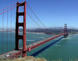
Golden Gate Bridge San Francisco's signature International Orange span is the city's majestic background, and about 10 million people a year head to the bridge for an up-close look. Walking the 1.7 mi to Marin County -- inches from roaring traffic, steel shaking beneath your feet, and a far-too-low railing between you and the water 200 feet below -- is much more than a superlative photo op (though it's that, too).
Fisherman's Wharf Once part of a thriving fishing industry, Fisherman's Wharf has deteriorated into a giant harpoon aimed straight at your wallet. Throngs from all over the world come to watch the flopping, barking, or napping sea lions; buy cheap T-shirts; and chow down on overpriced, mediocre food. It's all an utter mystery to locals, who don't come here. Ever. See the magnificent historic ships at the Hyde Street Pier, then take your money and run.
Golden Gate Park It may be world famous, but first and foremost the park is the city's backyard. Come here any day of the week, and you'll find a microcosm of San Francisco, from the Russian senior citizens feeding the pigeons at Stow Lake to the moms pushing strollers through the botanical gardens to the arts boosters checking out the latest at the de Young Museum. Be sure to visit the park's iconic treasures, including the serene Japanese Tea Garden and the beautiful Victorian Conservatory of Flowers. If you have the time to venture further into this urban oasis, you'll discover less-accessible gems like the Beach Chalet and the wild western shores of Ocean Beach.
Palace of Fine Arts Perched on a swan-filled lagoon near the Marina's yacht harbor, this stirringly beautiful terra-cotta-color dome has an otherworldly quality about it. Built for the 1915 Panama-Pacific International Exhibition, the palace is a San Francisco architect's version of a Roman ruin, and it's been eliciting gasps for almost a century. Try to see it from the water.
Coit Tower Most people assume that this stubby white tower atop Telegraph Hill is supposed to look like a fire hose. And considering that a fire truck-chasing, cross-dressing 19th-century socialite donated the funds to build it in honor of firefighters, maybe it is. The tower itself is of vague interest -- it does house the history of San Francisco in murals -- but the "park"(ing lot) at its base gives fantastic views of the city and the bay. The tower sits at the top of Telegraph Hill's Filbert Steps, a steep stairway through glorious gardens with vistas of transcendent beauty, an only-in-San Francisco spot locals cherish.
Cable Cars You've already seen them (on the big screen, in magazines, and, admit it, on the Rice-a-Roni ™ box). And considering a ticket costs $5 a pop, do you really need to ride a cable car? Yes, you do, at least once during your visit. Flag down a Powell-Hyde car along Powell Street, grab the pole, and clatter and jiggle up mansion-topped Nob Hill. Crest the hill, and hold on for the hair-raising descent to Fisherman's Wharf, with sun glittering off the bay and Alcatraz bobbing in the distance. Don't deny it -- this would be a deal at twice the price.
AT&T Park One of the finest examples of modern "retro" ballparks, the Giants coastal digs are the perfect place to spend a sunny afternoon enjoying the national pastime. Grab a dog and some garlic fries, and revel in the bay views. If you're lucky, you'll get to see someone drill a splash hit into McCovey Cove.
Yosemite National Park
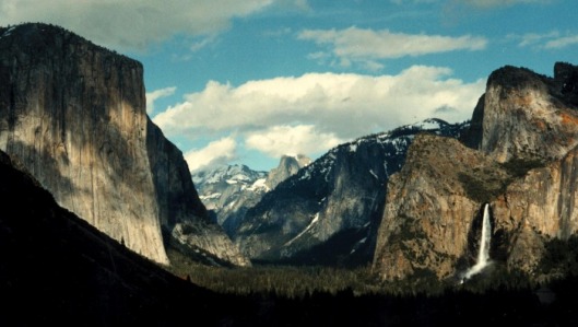
Below you'll find information about just a few of the numerous viewpoints around Yosemite National Park. Don't limit yourself to these viewpoints; whenever you see a turnout with an interesting view, pull into the turnout and take a look around--you never know what you might discover.
Half Dome, Vernal Fall and Nevada Falls, with the high country in the background
Glacier Point, some would say, is the most spectacular viewpoint anywhere. Most people agree that its views of the high country and breathtaking views of Yosemite Valley, including Half Dome and three waterfalls, are the most spectacular in the park. Washburn Point, just south of Glacier Point, has similar views, though the views of Vernal and Nevada Falls are a bit better. The road to Glacier Point is usually open late May or early June to sometime in November, though some people prefer to ski there in the winter.
El Capitan to the left, Bridaveil Fall to the right, and the rest of Yosemite Valley behind
Tunnel View provides one of the most famous views of Yosemite Valley. From here you can see El Capitan and Bridalveil Fall rising from Yosemite Valley, with Half Dome in the background. This viewpoint is at the east end of the Wawona Tunnel along the Wawona Road (Highway 41).
Clouds Rest (left) and Half Dome (right) at sunset
Olmsted Point, along the Tioga Road, looks down on Yosemite Valley from the east--and from a very different angle. Though you might not immediately recognize Half Dome, it is one of the most prominent peaks you can see from Olmsted Point. The Tioga Road is open to cars from late May or early June to sometime in November.
El Portal View, two miles up the Glacier Point/Badger Pass Road from Chinquapin (intersection with the Wawona Road) provides a great view down the Merced River Canyon, below Yosemite Valley, and to the Coast Ranges (if visibility is good).
Kolana Rock (right) and Wapama Falls (left) rise above Hetch Hetchy Reservoir
O'Shaugnessy Dam, at the west end of Hetch Hetchy Valley, provides a viewpoint of the Valley's waterfalls, rock formations, and reservoir. The Hetch Hetchy Road is open all year, though it may close for periods after snowstorms, and is open only during daylight hours (approximately).
As it approaches Yosemite Valley, turnouts along the Big Oak Flat Road (continuation of Highway 120 to Yosemite Valley) near the tunnels provide a great view of El Capitan and Half Dome, along with a glimpse of the Merced River far below.
Lembert Dome and peaks rise above greening Tuolumne Meadows
Pothole Dome, at the west end of Tuolumne Meadows, along the Tioga Road, affords many visitors' first view of Tuolumne Meadows. You can also find a nice viewpoint from near Lembert Dome, at the east end of Tuolumne Meadows
El Capitan rises over 3,000 feet above El Capitan Meadow
In Yosemite Valley, El Capitan Meadow provides a view straight up El Capitan and a great view of Cathedral Rocks, as well. Located along one-way Northside Drive, it is best to stop here on your way out of Yosemite Valley.
Beyond the Merced River are El Capitan (left) and Bridalveil Fall (right)
You can look up Yosemite Valley from alongside the Merced River at Valley View. Located along one-way Northside Drive, it is best to stop here on your way out of Yosemite Valley. This popular vista is located just after a view of Bridalveil Fall but immediately before Pohono Bridge, about the time you begin to see directional signs for highways leaving the park.
A boardwalk leads through a meadow toward Upper Yosemite Fall
In Yosemite Valley, the area around Sentinel Meadow and the Yosemite Chapel is a favorite place to stop to look at Yosemite Falls.
Half Dome reflected in Merced River
In Yosemite Valley, Sentinel Bridge is famous for its views of both Half Dome reflected in the Merced River. You can also see Yosemite Falls nearby.
Yosemite Falls; trailhead to Lower Yosemite Fall
Yosemite Lodge and Lower Yosemite Fall provide a closer view of Yosemite Falls. A short walk takes you right to the bottom.
Mariposa Grove
The trees in this grove are more than 3,000 years old, more than 50 feet around, and reach up over 300 feet seemingly to touch the sky. You can drive to the lower edge of the grove, but parking is strictly limited and you may wait in line for quite a while; better to take the free shuttle from the Wawona General Store, which departs every 15 minutes from 9a to 4:30p. Note: Trailers and motor homes are not permitted on the Mariposa Grove Road.
John Muir Vernal Falls Mist Trail Hike
This hike is also known as the Mist Trail because it passes right beside Vernal Falls, which in the spring blows a heavy mist everywhere. This 1.4 mile roundtrip hike is considered a moderate hike, with a steep 400-foot elevation gain in just over a mile. It is recommended that you wear shoes that grip as the path can be slippery. You can see the rushing water from the Vernal Falls Footbridge as well as the top of the falls in the distance. This is probably the busiest and most crowded hike in the Valley, small wonder given the loveliness of the trail. Plan on spending an hour or two on your walk. The trail may be closed
Half Dome Hike
If you are in very good shape and willing to spend a long day hiking, the difficult trek to the top of Half Dome may be for you. It is considered extremely strenuous, with an elevation gain of almost 5,000 feet. Start at Happy Isle Shuttle Stop Number 16 and work your way through the crowds visiting Vernal Falls, and begin a series of switchbacks to the top. The trail rises and falls a fair amount until you get close to Nevada Falls and from there the trail continues to Half Dome. Be warned, however, that the last 200 yards up the back of the dome require you to use steel cable handrails as you scramble up. Roughly 600 people make this trek every day in the summer, but it is not easy. Be sure to bring water, and wear a hat as well as comfortable walking shoes or boots. The trail may be closed in winter. Since this hike can take up to 12 hours to complete, it is recommended that you start early in the morning. For your safety it is best to complete this hike before dark. Check website for more information.
Glacier Point Trail Hike
This is a very strenuous hike; with an altitude gain of 3,200 feet. You may be disappointed when you get there because you will find that you could have reached the same place by bus. On the other hand, the trail is lovely, and you will feel virtuous because you spent four or five hours hiking. Take water with you and wear a hat as well as comfortable hiking shoes or boots. For your safety, it is recommended that you complete this hike before dark. The trail may be closed in winter.
Top of Yosemite Falls Hike
This very strenuous hike gains a total of 2,700 feet in altitude and gets quite steep towards the end. However, if you are in good shape and willing to spend most of the day on this endeavor, you will be delighted when you reach the top and see how Yosemite Falls braids the water as it leaps from rock to rock. You will also be rewarded with spectacular views of Yosemite Valley. Start at Sunnyside Camp 4 near Shuttle Stop 7. Bring water, and be sure to wear a hat and comfortable walking shoes or boots. This trail may be closed in winter. For your safety, it is recommended that this hike be completed before dark.
Camping
Camp 4
Location: Yosemite Valley, near Yosemite Lodge
Elevation: 4,000 ft (1,200 m)
Open: All year
Reservations: No, but the campground fills early most mornings from spring through fall.
Cost: $5/night per person (a total of six people will be assigned to each campsite)
Number of sites: 35
RV length: Not permitted
Trailer length: Not permitted
Parking: Parking is available adjacent to the campground. A parking permit is required from spring through fall. You will receive a free parking permit upon registering. Sleeping in vehicles is not permitted.
Groceries: Nearby (Yosemite Lodge, Yosemite Village)
Showers: Nearby (Curry Village and Housekeeping Camp)
Pets: Not permitted (learn more about pet regulations)
Each campsite contains a fire pit (no grill), picnic table, and four shared food lockers [33"(D)x45"(W)x18"(H)], and is near a bathroom with potable water and flushing toilets.
Camp 4 is listed on the National Register of Historic Places because of its nationally significant role in the development of rock climbing as a sport.
How to register at Camp 4
From spring through fall, a campground ranger staffs Camp 4 each day. You must register with the ranger in order to stay at Camp 4. The ranger arrives at the campground kiosk around 8:30 am, although, a line has often formed well before then and the campground may fill before everyone in line is registered. Space is available on a per-person basis and each person wishing to register must be present. Six people will be assigned to each campsite; people in one group may be assigned to different campsites.
Tamarack Flat Campground
Location: On the Tioga Road (Highway 120), about 45 minutes north of Yosemite Valley
Elevation: 6,300 ft (1,900 m)
Open: Late June through September (approximately)
Reservations: No
Cost: $10/night for each campsite (maximum 6 people per site)
Number of sites: 52
RV length: RVs not recommended
Trailer length: Trailers not recommended
Dump station: Yosemite Valley (Upper Pines Campground) or Tuolumne Meadows Campground
Groceries: Small grocery store at Crane Flat, about 15 minutes away
Showers: Yosemite Valley (Curry Village and Housekeeping Camp)
Pets: Not permitted (learn more about pet regulations)
Each campsite contains a fire ring, picnic table, and food locker [33"(D)x45"(W)x18"(H)], and is near a vault toilet. Stream water must be treated (by boiling, using a filter, or using iodine). No potable water available.
Yosemite Creek Campground
Location: On the Tioga Road (Highway 120), about one hour north of Yosemite Valley
Elevation: 7,700 ft (2,300 m)
Open: July through early September (approximately)
Reservations: No
Cost: $10/night for each campsite (maximum 6 people per site)
Number of sites: 40
RV length: RVs not recommended
Trailer length: Trailers not recommended
Dump station: Yosemite Valley (Upper Pines Campground) or Tuolumne Meadows Campground (about 30 minutes away)
Groceries: Small grocery store at Crane Flat or Tuolumne Meadows (about 30 minutes away)
Showers: Yosemite Valley (Curry Village and Housekeeping Camp)
Pets: Permitted (learn more about pet regulations)
Each campsite contains a fire ring, picnic table, and food locker [33"(D)x45"(W)x18"(H)], and is near a vault toilet. Stream water must be treated (by boiling, using a filter, or using iodine). No potable water available.
http://www.nps.gov/yose/planyourvisit/nrcamping.htm
Day Fourteen
Yosemite Again
Day Fifteen
L.A. and Malibu
Quintessential L.A. If you want to get a sense of local life, start by familiarizing yourself with these key influences. These are a few of the aspects that define L.A. -- and they're elements to take pleasure in, even if you're here for just a day.
Car Culture "Car culture" is not an oxymoron. Angelenos spend an enormous amount of time driving, and this influences far more than the city's legendary web of freeways and sprawling layout. Morning radio shows better be good, as they have to distract impatient drivers from rush-hour traffic jams. Joan Didion famously wrote about the hypnotic pull of the freeways. Commercial architecture started playing to drivers as early as the 1920s. First, business owners tried buildings that could be easily "read" and identified by people in passing cars -- one great example of this is the hot-dog-shaped Tail O' the Pup hot dog stand. Later, big plate-glass windows became popular so that drivers would get a tempting look at the illuminated store or restaurant interiors. There are the drive-through fast food spots, too, with their deep roots in convenience and pop culture. You'll see plenty of vintage cars on the road, from tenderly restored 1950s Chevys driven by car-clubbers to ironic, grungy, '70s Pontiacs. And let's face it: cars are one of the ways locals categorize and label each other, just as with clothes or music.
How about you? A convertible may cost more to rent, but what better place to drive one. If you've got green concerns, you can rent an ecofriendly hybrid vehicle, the wheels of choice for Cameron Diaz and Leonardo DiCaprio. Or maybe you'd like to splurge on a trendy sportscar, a knockout classic, or something exotic like a Maserati…. Whatever your pleasure, there are plenty of rental companies that can set you up.
The (Entertainment) Industry The Industry with a capital "I." It's the topic of most conversations you'll overhear; it leaves fingerprints all over local economics and politics; and it keeps local bloggers and gossips in a frenzy. Box office receipts grab headlines in the local newspapers and there's a constant stream of much-hyped opening weekends. Film awards season lasts longer than all the winter holidays put together. Sure, it's possible to have a conversation about the latest Salman Rushdie novel or an upcoming baseball trade. But sooner or later, it all comes back to the multiplex.
A massive chunk of the world's entertainment is developed, written, filmed, edited, distributed, and sold here. So why does it seem so difficult to find the heart of the Industry? Because most of it goes on behind closed doors. If you want a closer look, become a Method tourist! For instance, all movies start with an idea and ideas start with writers. Writers drink coffee. So spend some time at one of the city's many Coffee Bean & Tea Leaf cafés and there you'll see most of the WGA (Writers Guild of America) at work. You could do a fly-by at one of the major agencies, like CAA (Creative Artists Agency) in Century City -- and the nearby restaurants and take-out spots where assistants and agents scurry at lunch. But if you want to see some action, you'll likely have to pay for it, by hitting Warner Bros. Studios in the Valley or signing up as a TV audience member with Audiences Unlimited.
The Beaches There's something of a disconnect when it comes to L.A.'s beaches. Although hitting the beach is an integral part of life here, the coastline and the exclusive communities that front it somehow seem a bit removed from the rest of the city. Access to some beaches can be confusing (we're talking about you, Malibu), parking can be limited, and public services differ significantly. Unlike places like Miami, where the beach is basically an extension of the city, part of its "living room," the L.A. coast can feel like an entity unto itself. Each beach also has a distinct character, shaped by the surf quality (calm versus serious waves), the landscape, the facilities, and the beachgoers themselves. Do a little investigation before you commit to a certain beach: does it have what you're looking for? Also, keep in mind that the water quality can vary greatly depending on weather and other conditions -- for instance, storms can make things pretty mucky.
A Guide to SoCal Freeway Driving Sure, the veins of asphalt crisscrossing L.A. look innocent enough from your plane window. But down on the ground, those freeways can turn into a slow-moving mess of cars and cantankerous commuters jockeying for position. So how do you survive and conquer SoCal freeway driving if you're not a native?
Pick a lane. The car pool lane, the "fast lane," the truck lane, the merge lane -- this isn't your typical freeway. First of all, keep out of the two far right lanes. The California Department of Motor Vehicles restricts buses and trucks to these two truck lanes, which run slower than the regular speed of traffic. To drive at least the speed limit, get yourself in the middle lane. If you're ready to bend the rules a bit, the fourth lane moves about five miles over the speed limit. Newbies should stay out of the far left lane (the one that's next to the car pool lane). Speeds here range from 75 to 90, and besides that, you've got to deal with car-pool-lane mergers.
And what about that car pool lane -- also known as the diamond lane? Use it if you have two or more people in your car and it's moving faster than the speed of traffic; if Bus 187 to Pasadena is in it, don't. If traffic is light, stay in the main lanes. This gives you the freedom to change lanes when needed: car-pool lane entrances and exits are miles apart.
Speed, with caution -- but we didn't tell you that. Sure, you shouldn't go faster than the posted 65 or 55 mph. Easy to say, hard to do -- especially when everyone else seems to be doing it and getting away with it. If you want to keep up with the speed of traffic and avoid the prize of a speeding ticket, 70 to 74 mph is a good target range. If, however, you notice that you're passing lots of cars -- slow down!
Can't we all just be friends? Here's how to avoid causing road rage: Don't tailgate. Don't flail your arms in frustration. Don't glare at the driver of the car you finally have a chance to pass. And above all, don't fly the finger. Road rage is a real hazard.
Use your signal correctly. Here, signaling is a must. Because of all the different lanes, people may try to merge into the same spot as you from three lanes away. Protect yourself and your space by always using your signal. And don't forget to turn your signal off when the lane change is complete.
Get a freeway map. The small, laminated maps that just cover the jumble of freeways are indispensable if you merge onto the wrong freeway, get lost, or get stuck in traffic and want to find an alternative route. Nearly every gas station sells them; you can get a decent one for a few bucks.
Don't pull over on the freeway. Short of a real emergency, never, ever, pull over and stop on a freeway. So you took the wrong ramp and need to huddle with your map -- take the next exit and find a safe, well-lighted public space to stop your car and get your bearings.
Great Itinerary Classic L.A.: Stars, Cars & Vistas A car is virtually a necessity in L.A. (public transit is sparse and taxis are expensive and not that convenient). If renting a car, this is the perfect place to make it a convertible. Play for local sympathy and say you hail from a cold place and need solar therapy!
Day 1: Beverly Hills & the Getty Center Make like the Clampetts and head straight for the riches of Beverly Hills. Many of the stereotypes about Angelenos are rooted here. Hey, you're a visitor, you're allowed to indulge in some gawking! Do a bit of driving along Sunset Boulevard, perhaps dipping into Bel Air to see some of the over-the-top mansions. Then stretch your legs with shopping, real or window, on Rodeo Drive and Wilshire Boulevard.
Next up: a bird's-eye view of the city from the Getty Center in Brentwood. Wander among the stunning, travertine marble-clad pavilions and explore the gardens. And then there's the art, including exceptional European paintings and antique French furniture. But it's hard to tear your eyes from the view, especially at sunset. As the day winds down, splurge on a posh meal in Beverly Hills or West Hollywood.
Day 2: Culture Vulture Follow your artsy preferences to today's destination -- but wherever you end up, you're sure to defeat the old joke that L.A. is a cultural vacuum. The newest major museum is the revamped Getty Villa Malibu, dedicated to Greco-Roman antiquities. As with the Getty Center, the gardens and views are almost as mesmerizing as what's in the galleries. If you're a serious museum fan, consider the cluster along Museum Row, especially the LACMA. Or, you could drive inland to the Pasadena area to see the art and enormous gardens of the Huntington estate, plus the impressive European and Asian exhibits at the Norton Simon. Let your hair down at night (and rest your museum-fatigued feet) at a live-music or comedy club.
Day 3: Hit the Beach! Some cities have snow days but L.A. has beach days: parents pack up the car, make lunch, cancel lessons, and take the kids to the beach. Take a page from the locals and spend a day just enjoying the sun and sand. Before you pack your picnic, do some planning and pick a beach that suits your needs. Remember to bring cash for parking and, as Murphy's Law insurance, some books or games in case the water's too cold for much swimming. If you end up in Venice, you might want to rent bikes to ride along the boardwalk, and also spend an hour browsing in Abbot Kinney Boulevard's funky boutiques. If you're in Santa Monica, there's always the pier, with its old-school amusement-park rides.
Day 4: Downtown Bound Pick a weekday to venture downtown -- and wear comfortable shoes because unlike other parts of L.A., downtown is best explored on foot and on the DASH bus. Start at the Cathedral of Our Lady of the Angels (couldn't they just call it COLA?). You can see the Music Center, with the shining Walt Disney Concert Hall, on the way to the Museum of Contemporary Art. Not far from here is the Grand Central Market, where you might pick up a tamale or fresh fruit juice while eyeing the produce. Hop back in the car for the short drive to the grand Union Station; zip across to Olvera Street for a browse through the crafts market and perhaps an early Mexican dinner. Do you still have time for a performance at the Disney concert hall? Or a drink at the Millennium Biltmore (retro) or Downtown L.A. Standard (cutting-edge)? Hurry, back to the car!
Logistics: Downtown has some sketchy blocks, so use common sense. If you don't like the look of a certain street, turn around. There's also a DASH shuttle bus for short hops between sights.
Day 5: Hurray for Hollywood Over breakfast, check the Calendar section of the Los Angeles Times for showtimes at the old movie palaces like Grauman's Chinese or the El Capitan. (The Arclight is another top film spot.) Once you're in Hollywood, pay your respects to your favorite celluloid stars at their plaques on the Walk of Fame. Hit the Hollywood & Highland complex for a great view of the "Hollywood" sign and perhaps lunch at Vert. If you're a major movie buff, you may want to tour the complex's Kodak Theatre, where the Academy Awards are held, or spend an hour at the Hollywood Museum. Music fans should make time for the awesome Amoeba Records shop. If you'd like to do some funkier shopping, or try a low-key place for dinner, drive east on Sunset Boulevard to Los Feliz or Silver Lake. Somewhere in the day, take time out for a flick -- it's Hollywood, after all.
Camping
Johnson Valley State Off Highway Recreation Area State: California Nearest City: Victorville Nearest Town: Southeast of Victorville Cost: Free Number of Campsites: 30 or more Max days allowed: 30 Road: Dirt Miles from paved road: 2.00 Scenery Rating: 4 out of 5 Noise Level: 1 out of 5 Amenities: None Status: Official Months Open: Year Round Description State designated OHRA. Open desert. From I 15 exit #115, go east 23 miles and continue east on SR 247 (SR 18 will turn southeast). At 45 miles east of I 15, look for entrance to Johnson Valley SRA.
Stoddard Wells State Off Highway Recreation Area State: California Nearest City: Victorville Nearest Town: Northeast of Victorville Cost: Free Number of Campsites: 30 or more Max days allowed: 30 Road: Unknown Miles from paved road: 3.00 Scenery Rating: 4 out of 5 Noise Level: 1 out of 5 Amenities: None Status: Official Months Open: Year Round Description Open off road riding area where camping is permitted as well as riding off road vehicles. Can be hot in the summer. From I 15 exit #159, go south 2 miles and east on the paved then dirt road more than 3 miles. Camping is everywhere.
El Mirage Dry Lakebed Off Highway Area State: California Nearest City: Victorville Nearest Town: 10 miles northwest of Victorville Cost: Free Number of Campsites: 30 or more Max days allowed: 30 Road: Dirt Miles from paved road: 2.00 Scenery Rating: 4 out of 5 Noise Level: 1 out of 5 Amenities: None Status: Unknown Months Open: Year Round Description Dry lakebed that is closed in the winter if muddy. From I 15 and SR 395, take 395 N 13 miles, Crippen W 2.25 miles, Koala N 1 mile, El Mirage Blvd. west 4 miles to designated entrance. 10 square miles of camping areas; hot in the summer. Lakebed can be closed if wet, but allows camping around the outside of the lake.
