Day Sixteen
Las Vegas
Fountains at the Bellagio
A visual water symphony choreographed to music provides an unforgettable welcome to the Bellagio Hotel Casino . The water jets span more than 1000 feet and can shoot up to 250 feet in the air while seeming to dance to choreographed lights and romantic classical music. It is a spectacular sight and one worth taking the time to view while strolling along the boulevard. Be sure to bring a camera as this is one of Vegas's best attractions; not to mention, it is also free! Every 30 minutes until 7p, after which shows are every 15 minutes.
Bellagio has earned the prestigious AAA Five Diamond award for 2008, making this the sixth time the property has received this award. Bellagio combines Old World elegance with modern luxuries in a 3,933 room resort in the heart of the Las Vegas Strip.
The Tuscan-themed resort transports guests to the Vegas version of the famous town on Italy's Lake Como. Dancing water choreographed to popular music and show-tunes soars 240 feet above an eight-acre lake, surrounded by deluxe guest rooms and suites, abundant dining, entertainment, shopping and gaming options.
While you may not want to leave your posh accommodations, with contemporary custom furniture, fine art, sunken bathtubs and such conveniences as high-speed Internet access, there's much to see and do, eat and buy here.
The Conservatory and Botanical Gardens present fresh displays of foliage with the changing seasons, cultivated from a 90,000-square-foot greenhouse located behind the hotel.
The Bellagio Gallery of Fine Art exhibits paintings, sculpture and works on paper by the world's most influential artists.
The international cast of Cirque du Soleil's "O" - synchronized swimmers, divers, acrobats and aerialists - performs in a theatre reminiscent of the Paris Opera House. Or you can revel in live music and views of Lake Bellagio at Fontana bar.
Guests of the Bellagio dine at some of the world's best restaurants: The Maccioni family's Le Cirque (an AAA Five Diamond award-winner) and Osteria del Circo, Todd English's Olives, the seafood restaurant Michael Mina by Michael Mina, Jean-Georges Vongerichten's Prime steak house, and James Beard award-recipient Julian Serrano's Picasso, featuring a collection of the artist's masterworks.
Along Via Bellagio, you'll find such upscale boutiques as Giorgio Armani, Chanel, Prada and Tiffany & Co.
In the spacious, European-inspired casino, try your luck at blackjack, European roulette or pai gow, or in the popular poker room or the race and sports book.
Lounge by the pool in a Mediterranean Villa-style setting with relaxing pools, soothing spas and private cabanas surrounded by citrus and parterre gardens.
If work's a must, there's more than 200,000 square feet of fully-equipped convention space and a professional staff on hand to oversee every detail.
Other hotel amenities include the 65,000 square foot Spa and Salon Bellagio, the lovely wedding chapel and Terrace of Dreams, and access to Shadow Creek, one of the country's most exclusive golf courses.
Caesar's Palace
Celebrating the glory of Rome, Caesars Palace has been a must-see destination resort since it opened in 1966. Located in the heart of the Las Vegas Strip, those famous fountains, dramatic gabled pediments and Corinthian columns are world-renowned.
A renaissance that began in 2000 has elevated its status even higher. The addition of the $95 million Colosseum brought superstar performers like Elton John, Bette Midler and Cher. Celebrity chefs Bradley Ogden and Bobby Flay joined Caesars with the opening of Ogden's namesake restaurant, and Flay's Mesa Grill, his first restaurant outside New York. The Forum Shops at Caesars added 60 new upscale retailers to an existing group of 100 shops during its recent expansion including Kate Spade, Juicy Couture, CH Carolina Herrera and Harry Winston. The addition of a five-acre, open-air Roman Plaza features the Italian trattoria Viale, which overlooks the Strip as well as an outdoor event amphitheatre.
The A-list Pure Nightclub made its debut on New Year's Eve, and includes the Vegas version of the famous Pussycat Dolls Lounge. As if that was not enough, French chef Guy Savoy opened a restaurant on the property's new luxury 949-room Augustus hotel tower.
The 2,400 elegant guest rooms and suites feature such standard amenities as marble- finished bathrooms, soaking tubs, in-room televised gaming instruction and high-speed Internet access. Deluxe suites include such lavish accoutrements as private dining rooms, wet bars, saunas, steam rooms, home-theater systems, putting greens and workout rooms. The penthouse suite, with butler, security and attendant services, are a sight only for the super elite.
Inspired by Rome's famed Baths of Caracalla, the "Garden of the Gods" offers a refreshing break from the desert heat with four swimming pools surrounded by graceful fountains and classic statues. Relax in the private oasis of the Venus Pool, which offers guests 21 and over a serene escape from the traditional hectic pool experience. Two outdoor wedding chapels overlook the lush grounds.
There is an excellent health spa and beauty salon; Over 190,000-square-feet of premium meeting and convention space; and more than 128,000 square feet of gaming space with the Palace, Forum and high-limit Palace Court casinos full of table games, high-tech slots and poker room.
For a taste of Caesars legendary past, dine at Neros steak house and dance the night away on Cleopatra's Barge Nightclub, a floating cocktail lounge.
Circus Circus
Since 1968, Lucky the Laughing Clown, towering 123 feet over Las Vegas Boulevard, has beckoned those strolling along the Las Vegas Strip to step inside the Circus Circus hotel's legendary Big Top, where you'll find carnival games and craps, high-flying aerialists and juggling cocktail waitresses.
Trapeze artists, acrobats and clowns still perform on the Midway Stage daily from 11 a.m. to midnight above the casino. There's still a huge carnival midway where players can win large stuffed animals in a variety of traditional games. And the famous Horse-A-Round Bar - a watering hole on a spinning carousel - is still the hardest bar in town to walk away from - especially after a few Pink Elephants (pink lemonade, vodka, grenadine, ginger ale, and an optional cherry and parasol).
The Adventuredome at Circus Circus features 16 rides and attractions, including the world's only double-loop, double corkscrew roller coaster, the Canyon Blaster, as well as a traditional carousel, bumper cars, midway games and clown shows for younger kids.
Really, you could think of the whole hotel as America's largest indoor theme park, with more than 3,750 guest rooms and suites - hospitality suites, parlor suites and Jacuzzi suites - and the Circus Circus Manor, with convenient motor lodge-style parking. The 399-space Circusland recreational vehicle park offers a 24-hour convenience store, game arcade, coin-operated laundry facilities, pool, Jacuzzi saunas, playground and pet runs.
The world-famous Circus Buffet serves an average of 8,000 customers per day - perhaps the busiest buffet in the world.
Excalibur
The Excalibur Hotel transports you back to the mythical days of King Arthur- mythical draw bridges, castle turrets, and shining armor. This "marvel of modern imagination" recreates the magic of medieval times with the "Tournament of Kings Dinner Show," and the Canterbury Wedding Chapels inside a hotel-casino complete with modern luxury amenities.
The Fantasy Faire Midway features medieval-themed games, Magic Motion simulator rides, an arcade and dozens of shops and restaurants.
An invitation to dine at King Arthur's table is a time-tested tradition of the highest of honors. And, at the "Tournament of Kings" dinner show, an original music production adapted from the legend of King Arthur, you can feast on a three-course meal in a theater-in-the-round, where jousting knights on horseback battle dragons, evil wizards and each other to save damsels in distress. If the meal on the plate is entertainment enough, try the equally medieval Steakhouse at Camelot, Regale Ristorante Italiano, Sherwood Forest Cafe or RoundTable Buffet. Dick's Last Resort is the latest addition to Excalibur with its zany wait staff and deliciously messy cuisine.
The Canterbury Wedding Chapels provide fairytale nuptials in two ornate chapels with cathedral-style vaulted ceilings, stained glass windows and arched entrances. The bride and groom can even re-enact the wedding of Arthur and Guinevere dressed in authentic period attire.
Before you tie the knot, why not treat your bridesmaids to the steamy "Thunder From Down Under." Australia's all-male revue takes its armor off nightly in Merlin's Theater. Finally, treat yourself like royalty with many relaxing options; choose room service in one of nearly 4,000 guest rooms, pamper yourself in the Royal Treatment Spa & Fitness Center, lounge by the pool or take advantage of the free blackjack lessons in the casino. Excalibur is also one of the few hotels that offers PokerPro tables. These automated poker tables allow for faster play and more people per table. Experience the newest sensation in Poker. There is nothing medieval about that.
Luxor
One of the most recognizable structures in Las Vegas, the Luxor Hotel stands majestically among the best in themed hotels. With its identifiable pyramid and illuminating spotlight emanating from its apex, the Luxor is one of the few man-made structures visible from space.
Aside from its dramatic exterior features, Luxor provides an even more awe-inspiring sight as guests step inside and witness the world's largest open atrium. With more than 4,400 guest rooms-473 suites-the hotel provides much more than luxurious room accommodations, top-notch room service, and impeccable customer service. From electrifying entertainment and nightlife, to relaxing spas and signature restaurants, Luxor offers guests a unique and memorable visit.
There's no shortage of options when it comes to entertainment. Comedy takes center stage as Carrot Top's one-man prop bonanza keep visitors rolling in the aisles. Late night bares all as the sexy and provocative girls of Fantasy indulge guests in their wildest dreams!
Celebrity magician/actor/musician Chris Angel opened his grand illusion show in conjunction with the creative force of Cirque du Soleil to re-define the traditional magic show. After five years of research and development, the show will incorporate Angel's mystifying illusions with acrobatics, dance, puppetry and music.
After an extensive remodel, Luxor is now a hip and contemporary property offering new concepts in its nightclubs and lounges. As the centerpiece for the hotel, Liquidity is a dynamic bar that brings water to life through cutting-edge technology-a high-tech projection system where water is the canvas. The main lobby bar, Aurora, brings the Northern Lights experience to the hotel's energy 24 hours per day. Both LAX nightclub and the Flight bar offer a lively and decadent decor for the social crowd.
Whether seeking a relaxing day at Nurture Spa or dining at an eclectic restaurant like Company American Bistro, Cathouse you can definitely fulfill your desires at Luxor.
MGM Grand
The MGM Grand Hotel and Casino in Las Vegas has been nicknamed "The City of Entertainment" for good reason. Atop a 25-foot pedestal framed by LED screens advertising the goings-on inside, the 100,000-pound MGM lion roars above the Las Vegas Strip. And, as expected, entertainment choices abound.
The Lion Habitat, home to six adult lions, includes the direct descendants of the MGM Studio's marquee lion. The latest creation from Cirque du Soleil, "Kà", combines acrobatic performances, martial arts and pyrotechnics. The 17,157-seat Grand Garden Arena hosts performances by Madonna, the Rolling Stones and Rod Stewart, championship boxing and nationally-televised awards shows; Tom Jones, David Copperfield headline the more intimate Hollywood Theatre. The three-story Studio 54, located in the heart of the hotel's casino, pulsates with pop and cutting-edge house music. (The gallery of vintage black-and-white photographs harkening back to the heyday of the original "54" in NYC is a must-see.) And, finally, CBS Television City, the station's first research center, screens television pilots.
The excitement spills out onto the casino floor with such gaming classics as blackjack, baccarat, roulette and craps, poker rooom, the latest slots and a state-of-the-art race and sports book.
If you have time to sleep, four 30-story towers house more than 5,000 guest rooms, including those housed in Mobil Travel Guide's Four-Star recipient Skylofts - a luxury, loft-style boutique hotel occupying the top two floors of MGM Grand - as well as 751 suites and 29 private villas in The Mansion at MGM Grand.
The newly expanded restaurant offerings include sushi and teppan specialties in Shibuya, also home to Vegas' first sake cellar; Chef Michael Mina's "jet fresh" seafood at Seablue; a stylish outpost of restaurateur Stephan Hanson's Fiamma Trattoria; and Craftsteak by Chef Tom Colicchio; which join a remodeled Wolfgang Puck Bar & Grill and Emeril Lagasse's New Orleans Fish House. More casual dining options include The Rainforest Café, Stage Deli and the MGM Grand Buffet.
The Grand Pool complex is just that - 6.6 acres of grand swimming pools, whirlpools and a lazy river. The Grand Spa Salon & Fitness Center features more than 30 treatment rooms, saunas and steam rooms, the steady hands of celebrity stylist Cristophe, and high-tech virtual-reality climbers and bikes.
The Forever Grand Wedding Chapel has two full-service, non-denominational chapels that can accommodate up to 60 guests. Plus, the $100 million MGM Grand Conference Center offers meeting space in excess of 500,000 square feet, accommodating up to 10,000 people.
Such conveniences as the monorail station, which connects nine major resorts along its four-mile route, and satellite hotel check-in at McCarran International Airport make getting around even easier.
Mirage
The Mirage hotel introduced the concept of destination resort to Las Vegas and recently underwent a stunning transformation to maintain its preeminent position in what has become an increasingly competitive market. While introducing contemporary amenities designed to recapture the resort's leading-edge position, The Mirage maintains the exceptional service standards and sophisticated atmosphere that have distinguished it as a AAA Four Diamond Luxury Resort and Casino.
Once inside, a sun-lit atrium welcomes you with palm trees towering above waterfalls and pools. The Mirage aquarium displays new, brighter artificial corals and hundreds of unique sea creatures that evoke the exotic beauty of such tropical locales as Australia's Great Barrier Reef.
The Mirage's 3,044 guest rooms and suites have undergone a $110 million renovation. The new rooms will feature simple lines with an ergonomic design detailed to give a high-end feel, while warm woods and a bold color scheme transport the rooms into the realm of chic. Ultra-modern upgrades and amenities including LCD TVs and iHome MP3 docks provide everything necessary for a truly lavish experience to cater to both the leisure and business traveler.
The Mirage offers the latest in spa procedures and pampers the most discriminating guests. Celebrity stylist Kim Vo Salon provides the latest hair treatments, manicures, pedicures and personalized makeup services. From therapeutic massages to soothing facial treatments, enjoy the new Spa at the Mirage.
Entertainment by day or night will leave any guest with great memories. Several pools are surrounded in lush tropical environs; including the adult alternative Bare Pool with exclusive access and VIP service. Cirque du Soleil's "LOVE" production is a jaw-dropping re-creation of classic Beatles songs in a multi-million dollar custom theater. America's Got Talent Winner Terry Fator, the hotel's resident impressionist/comedian/singer/ventriloquist, is one man with spot-on impersonations; The show is scheduled to open February 2009.
There is no shortage of fine dining with food from around the world; Kokomo's steak and seafood, Onda Ristorante's Italian-American fare, Japonais' modern contemporary cusine, and New York's Carnegie Deli offer unique and award-winning cuisine.
On the wilder side, legendary performers Siegfried and Roy are the namesakes of the Secret Garden-home to White Lions, Royal White Tigers, Atlantic Bottlenose Dolphins and many more exotic animals.
New York-New York
The best of the Big Apple buzzes inside the New York-New York Hotel and Casino on the Las Vegas Strip. The trip begins with a stroll across a 300-foot Brooklyn Bridge, past facades of 12 New York-style skyscrapers (all one-third scale, including a 47-story Empire State Building) and ends at a 150-foot Statue of Liberty.
The other city that never sleeps, Las Vegas' homage to NYC - one of the Strip's more clever displays of themed architecture - even has a Coney Island-style roller coaster (The Roller Coaster, which twists, loops and dives around the property) and replicas of Grand Central Station and Ellis Island.
The towers house over 2,000 guest rooms, including more than 1,300 recently remodeled Park Avenue deluxe guest rooms and over 190 suites, and a pool, spa and salon. Interiors mimic Manhattan's Park Avenue (retail shops plopped inside famous NYC storefronts), Central Park (a casino floor dotted with autumnal trees draped in twinkling lights, a reflecting pond and stream), Times Square (signs that advertise "what to do" in New York-New York) and the Financial District (cashier cages beneath Wall Street veneers).
Just like the melting pot that inspired it, New York-New York takes its dining cues from around the world. For authentic Italian regional recipes, try Il Fornaio. An NYC landmark since 1927, Gallagher's Steakhouse serves up prime, dry-aged beef and fresh seafood. The two-story Nine Fine Irishmen pub offers authentic Irish food, drink and music. ESPN Zone bridges the gap between dining and entertainment with a menu of American grill classics, 165 TV monitors (including two 14-foot big screens) and loads of interactive games and attractions.
Set against the backdrop of famous New York landmarks, the casino integrates over 80 table games, 1,800 slot machines and TVs broadcasting major sporting events in a blur of action.
Another side of Cirque du Soleil, "Zumanity" delivers an erotic, adult-oriented cabaret-style show. The Bar at Times Square and Coyote Ugly deliver atypical watering hole entertainment. And the young at heart flock to the Coney Island Emporium, an entertainment center that recreates the aura of the amusement park with midway-style carnival games, bumper cars and shooting galleries.
Perhaps the replica most-worth seeing, though, is the September 11 tribute (located at the base of the Statue of Liberty) scattered with mementos placed by visitors - notes, flowers, flags and poems.
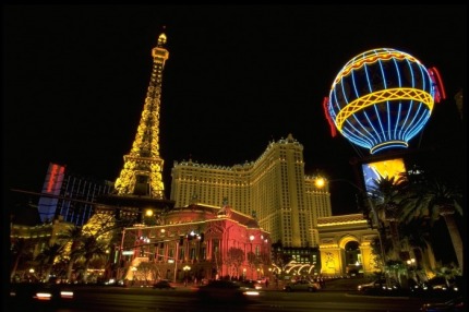
Paris
Two of the world's most exciting cities combine to create the Paris Las Vegas hotel and casino, a vacation destination that's full of romance, adventure and extraordinary dining.
In this version of the City of Light, you can hit the highlights in no time. As part of its architecture, the resort has detailed replicas of the Arc de Triomphe, Louvre façade, Paris Opera House and Hotel de Ville. And you certainly can't miss the 50-story, half-scale replica of the Eiffel Tower, now one of Las Vegas' most famous landmarks.
Ride with the elevator operator/tour guide to the tower's top-floor observation deck, where you can see practically all of Las Vegas. On the way down, at the 11th floor, the Eiffel Tower Restaurant serves up a dining experience you'll never forget, including breathtaking views of the Strip and mouthwatering cuisine from France.
At the base of the tower lies an expansive casino, whose theme features fountains, statues and vaulted ceilings. A cobblestone path lined with wrought-iron streetlamps guides you around the tables and 1,700 slots, poker room, as well as over to the race and sports book. Down Le Boulevard is the shopping district, where strolling mimes and bicycling bread men roam the store-lined village streets, and the statues come to life. Here's the place to buy a Vegas-style souvenir from Paris - or a little something at one of the boutiques. You'll find it hard to pass by the aromas coming from an authentic French bakery (JJ Boulangerie) and bistro (Le Creperie).
The resort has many more dining options. Among its 10 restaurants are Les Artistes, the opulent two-level steakhouse featuring generous portions and Impressionist art; and Mon Ami Gabi, where you can dine on the amazing steak frites al fresco along the heart of the Las Vegas Strip. Le Burger Brasserie features the most creative burgers.
The night is always young in Paris Las Vegas, and there is an exciting way to spend it - wisely or otherwise. The chic Risqué nightclub, you can experience Vegas "night culture" at its finest until the wee hours.
Come bedtime, the 2,900 rooms are all spacious and finely appointed, and the suites that much more, with custom furnishings and marble bathrooms. Hotel amenities include a wedding chapel, business center, swimming pool, fitness center and the Spa by Mandara, a 26,000-square-foot Balinese-style health and beauty retreat.
Day Seventeen
Hoover Dam
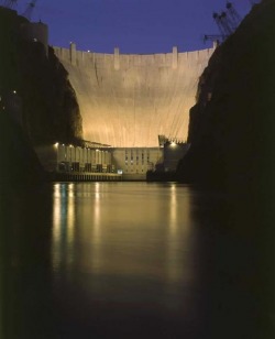
Hoover Dam, originally known as Boulder Dam, is a concrete arch-gravity dam in the Black Canyon of the Colorado River, on the border between the U.S. states of Arizona and Nevada. When completed in 1935, it was both the world's largest electric-power generating station and the world's largest concrete structure. It was surpassed in both these respects by the Grand Coulee Dam in 1945. It is currently the world's 35th-largest hydroelectric generating station.[3]
This dam, located 30 miles (48 km) southeast of Las Vegas, Nevada, is named after Herbert Hoover, who played an instrumental role in its construction, first as the Secretary of Commerce and then later as the President of the United States. Construction began in 1931 and was completed in 1935, more than two years ahead of schedule. The dam and the power plant are operated by the Bureau of Reclamation of the U.S. Department of the Interior. Listed on the National Register of Historic Places in 1981, Hoover Dam was designated a National Historic Landmark in 1985.[1][4]
Lake Mead is the reservoir created behind the dam, named after Elwood Mead, who oversaw the construction of the dam.
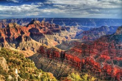
Grand Canyon
Rim Trail
The Rim Trail extends from the village area to Hermits Rest. Begin from any viewpoint in the village or along Hermit Road. The Rim Trail offers excellent walking for quiet views of the inner canyon and for visitors who desire an easy hike. No water west of Bright Angel Lodge. By using the shuttle buses, you can customize your hike to meet your needs. Part of the trail is paved and accessible.
Bright Angel Trail
(Steep) The Bright Angel trail begins just west of Bright Angel Lodge and offers day hikes that range in distance up to 12 miles (round trip). Some shade. Seasonal water subject to pipeline breaks. Check at the Visitor Center or Backcountry Information Center for water status. Upper portion of the trail may be extremely icy in winter or early spring.
South Kaibab Trail
(Steep) The South Kaibab Trail begins south of Yaki Point on Yaki Point Road. Access to the trailhead is by shuttle bus (Kaibab Trail Route). Offers day hikes that range in distance up to 6 miles (round trip). Best views for a relatively short hike. Steep trail, no water, little shade. Water available seasonally at the trailhead. Upper portion of the trail may be extremely icy in winter or early spring.
Hermit Trail
(Steep) The Hermit trail offers hikes to Santa Maria Spring, 5 miles (round trip), and Dripping Springs, 7 miles (round trip). Trail conditions are tougher than the Bright Angel and South Kaibab trails. Unmaintained steep trail requires caution. Begins 500 feet west of Hermits Rest. Water from springs must be treated before drinking. For experienced desert hikers. Hiking boots recommended.
Grandview Trail
(Very Steep) The Grandview trail offers hikes to Coconino Saddle, 2.2 miles (round trip), and Horseshoe Mesa, 6.4 miles (round trip). Trail conditions are tougher than the Bright Angel and South Kaibab trails. Unmaintained steep trail requires caution. Begins on canyon side of retaining wall at Grandview Point on Desert View Drive (12 miles east of village). For experienced desert hikers. Hiking boots recommended.
The South Rim and Desert View
Canyon View Information Plaza overview.
Canyon View Information Plaza
Canyon View Information Plaza
Visit the visitor center and bookstore at Canyon View Information Plaza — only accessible by free shuttle bus, a one-mile walk or bicycle ride from Market Plaza on the Greenway Trail, or a short walk from Mather Point. During the winter months, the Visitor Center is open daily from 9:00 a.m. to 5:00 p.m. The bookstore is open daily from 8:00 a.m. to 5:00 p.m. Outdoor exhibits may be viewed anytime.
Verkamps Visitor Center
Verkamp's Visitor Center
Stop by Verkamp's Visitor Center, a short walk east of the El Tovar Hotel and Hopi House, the canyon's newest visitor contact station in one of its oldest buildings. At the information desk, National Park Service rangers and Grand Canyon Association staff will answer any questions you may have. From the Verkamp's Visitor Center, the Rim Trail leads to other businesses and viewpoints along the rim. Open daily 8:00 a.m. to 5:00 p.m.
Pioneer history exhibits
Pioneer History Exhibits
The Verkamp's home and business was constructed in 1906, and it was open as a gift shop (that featured Grand Canyon souvenirs and Native American arts and crafts) through September 17, 2008.
Verkamp's re-opened as a visitor center on November 26, 2008. The National Park Service now owns the building and it hosts a bookstore and exhibits about the pioneer history of Grand Canyon Village. Several ranger-conducted activities start here.
The great gorge is accessible from two sides, north and south. Most of the more than five million visitors per year choose to go to the South Rim, which has many more tourist facilities than the north side and, accordingly, tends to get action-packed during the summer season and even some winter weekends. The North Rim is a quieter and more remote place and preferred by people who wish for a more serene, less crowded experience.
The access road to the North Rim is frequently closed during winter due to snow. Both rims can get very cold in the winter, and nights are cool even during summer months. Hiking inside the canyon below the rim, however, is quite another story, as summer temperatures near the Colorado River at the bottom may reach 120 degrees Fahrenheit. Hikers, in particular, will face extreme changes in climate and should be prepared for these.
THE SOUTH RIM
Tusayan
If you, like the majority of visitors, approach the canyon from the south on Highway 180 via the nearby towns of Flagstaff or Williams, you will most likely stop at Tusayan, a commercial area consisting mainly of gas stations, motels, fast food restaurants and the Grand Canyon Airport. The main attraction here, however, is the Grand Canyon IMAX Theater , which is highly recommended. The theater features one of the best films in the nature genre, drawing you right into the chasm and taking you on a vertiginous flight between the canyon's walls. A few miles further north, at the park gate, you will be requested to pay your $20 entrance fee per vehicle, or $10 per individual (pedestrian, bicycle, etc.). An Annual Grand Canyon Pass is available for $40.
Grand Canyon Village
Your first stop inside the park should be the Park Headquarters and Visitor Center , where an abundance of books, films and slides will help you to get better acquainted with the park, and rangers will be available to answer any Grand Canyon question you might have. You can stock up on supplies at Canyon Village Marketplace & Deli just south of the Visitor Center , then go on to see the historic El Tovar Hotel . For those who don't suffer from vertigo, the Grand Canyon Skywalk offers a breathtaking view of the chasm through its glass bottom. From the village, you have the choice of exploring the canyon using either the West Rim or the East Rim Drive.
East Rim Drive
This 26-mile drive skirts most of the canyon's south rim, offering several overlooks to get a better view. Among the best viewing areas en route are Yaki Point , thrusting out beyond the rim for a good look at canyon formations, and Grandview Point with its panoramic wide-angle views. A visit to the Tusayan Ruins and Museum provides fascinating information about the ancient Native American cultures in the area. The drive ends at the Watchtower at Desert View, a visitor complex containing services and a campground with views of the Painted Desert to the east and the Colorado River deep down inside the gorge.
West Rim Drive
This drive stays a little closer to the edge than its eastern counterpart and also offers a greater variety of canyon views. Note that it is closed to private vehicles in the summer, when a free shuttle service from Grand Canyon Village takes over transportation, meaning you can always hop on the bus if you get tired after choosing to hike the eight-mile Rim Trail .
THE NORTH RIM
While the South Rim is open 24 hours, 365 days a year, facilities on the north side close down from late October to mid-May. You can still visit the North Rim in winter, provided the access road is not closed by snow, but be advised to bring a thermos with hot coffee or tea! The best time for visiting the North Rim is actually the fall season, when the Kaibab National Forest turns into a dazzling showcase of yellow leaves trembling on aspen trees. A cross-canyon shuttle connecting north and south rim in both directions is available May through October for $60 one way, $100 round trip.
Visitor facilities on the northern edge are all clustered in the relatively small area around Grand Canyon Lodge , a rustically elegant castle-style hotel with terrific views from its terraces and dining rooms. It's also the North Rim's visitor center, booking center for mule rides and various other activities. A quarter-mile paved trail leads from the Grand Canyon Lodge to Bright Angel Point , famous as the best spot for seeing sunsets and sunrises over the canyon.
Trails
The inner canyon is accessible by so-called 'Corridor Trails' connecting the rims. The trailhead for the North Kaibab Trail is about two miles north of the North Rim visitor area. The North Kaibab Trail descends deep into the canyon, then links with Bright Angel Trail for the steep ascent up the South Rim. It is one of the busiest trails, but there are many less-traveled trails in remoter areas of the canyon. Keep in mind that all hiking in the Grand Canyon is strenuous, and it is imperative to carry plenty of water, food snacks, sunscreen and, vitally important in the summer, a shade hat. Also remember that the Backcountry Office requires a permit for overnight travel below the rim ($20 per person).
Jacob Lake
This is a small settlement at the intersection of U.S. 89A and State Route 67, the road leading to the North Rim. It's also the place where you might end up staying overnight if you haven't made reservations for camping or lodging in the summer. The Forest Service's Jacob Lake Campground is usually available till late afternoon, and you still may find vacancies at the commercial Kaibab Lodge Camper Village. From here all the way to the canyon is a huge area of still largely unexplored wilderness, with trails where you're more likely to meet squirrels, deer, bears and mountain lions than humans.
Rim Trail
Running parallel to the South Loop Road, which is open to vehicular traffic, this trail comes about as close to the Canyon's edge as it is safe to saunter. Classified as a "moderate" trail, it is the perfect choice for a less challenging foray and an ideal walk for kids. The trail extends from Yavapai Point on the east end of the Village to Hermit's Rest on the west. It is an 18-mile round trip, but you can also catch a shuttle bus back to town, if you like. Along the way, you will pass the most popular South Rim attractions.\
Grand Viewpoint
At 7,406 feet, Grandview Point is one of the highest lookouts along the south rim, providing sightseers with a unique view looking down on the mountains. Due to its altitude, it receives more moisture, which in turn brings more vegetation than to other areas along the south rim. This is where Grandview Trail descends into the canyon to take hikers by the site of the old Grandview Hotel, one of the original tourist facilities in the late 1800s.
Camping
Jacob Lake State: Arizona Nearest City: Page Nearest Town: Jacob Lake Cost: $10 or less Number of Campsites: 30 or more Max days allowed: 14 Road: Paved Miles from paved road: Unknown Scenery Rating: 5 out of 5 Noise Level: 1 out of 5 Amenities: Water, Electric, Dump Station Status: Official Months Open: May through October? Description The campground is composed of five loops: A through E, adjacent to US Route 89A among Ponderosa pines of various ages. It is located 32.6 miles north of Grand Canyon's north rim and one mile from Jacob Lake. An interpretive program is offered throughout the summer; contact the Kaibab Plateau Visitor Center (in town of Jacob Lake) for locations and times. The campground can accommodate any size RV. Jacob Lake Lodge with cafe, limited groceries and gas is located nearby. Visit Jacob Lake (off Forest Route 461) to view wildlife and visit the old ranger station which is on the National Register for Historic Places. A nice day hike from the campground is one of the six sections of the Kaibab Plateau Trail (part of the Arizona Trail); obtain information from the Kaibab Plateau Visitor Center. Horse rentals and chuckwagon rides/meals are available nearby.
Day Eighteen
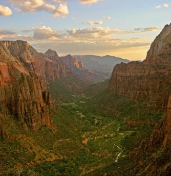
Zion National Park
Zion Canyon Visitor Center
Open: Daily
Closed: December 25
Spring: 8:00 a.m. to 6:00 p.m.
Summer: 8:00 a.m. to 7:00 p.m.
Fall: 8:00 a.m. to 6:00 p.m.
Winter: 8:00 a.m. to 5:00 p.m.
Private Vehicles/RVs
$25 per vehicle-7 day pass
Car/Motorcycle:
I-15 passes west of the Park and connects with UT-9 and 17 to the Park. US-89 passes east and connects with UT-9 to the Park. The Zion Canyon Visitor Center is a short distance from the Park's South Entrance adjacent to Springdale. The Visitor Center at the Kolob Canyons entrance is accessible from I-15, exit 40.
Zion NP Travel Guide
The walls of Zion Canyon soar more than 2,000 feet above the valley below, but it's the character, not the size, of the sandstone forms that defines the park's splendor. The domes, fins, and blocky massifs bear the names and likenesses of cathedrals and temples, prophets and angels. But for all Zion's grandeur, trails that lead deep into side canyons and up narrow ledges on the sheer canyon walls reveal a subtler beauty. Tucked among the monoliths are delicate hanging gardens, serene spring-fed pools, and shaded spots of solitude. So diverse is this place that 85% of Utah's flora and fauna species are found here. Some, like the tiny Zion snail, appear nowhere else in the world.
At the genesis of Zion is the Virgin River, a tributary of the Colorado River. It's hard to believe that this muddy little stream is responsible for carving the great canyon you see, until you witness it transformed into a rumbling red torrent during spring runoff and summer thunderstorms. Cascades pour from the cliff tops, clouds float through the canyon, and then the sun comes out and you know you are walking in one of the West's most loved and sacred places. If you're lucky, you may catch such a spectacle, but when the noisy waters run thick with debris, make sure that you keep a safe distance -- these "flash floods" can, and do, kill.
The park comprises two distinct sections -- Zion Canyon, and the Kolob Plateau and Canyons. Most people restrict their visit to the better-known Zion Canyon, especially if they have only one day to explore, but the Kolob area has much to offer and should not be missed if time allows. There's little evidence of Kolob's beauty from the entrance point off Interstate 15, but once you negotiate the first switchback on the park road, you are hit with a vision of red rock cliffs shooting out of the earth. As you climb in elevation you are treated first to a journey through these canyons, then with a view into the chasm. Due to geography -- no roads connect Zion Canyon with Kolob Canyon -- and to access points that are far apart, it is not feasible to explore both sections in one day.
Kolob Canyons Road
Rate It
* Address: Kolob Canyons Rd. east of I-15, Exit 40, Zion National Park, UT | Map It
* Category: Scenic Drives
* Location: Zion NP
Fodor's Review:
From Interstate 15 you get no hint of the beauty that awaits you on this 5-mi road. Most visitors gasp audibly when they get their first glimpse of the red canyon walls that rise suddenly and spectacularly out of the earth. The scenic drive winds amid these towers as it rises in elevation, until you reach a viewpoint that overlooks the whole Kolob region of Zion National Park. The shortest hike in this section of the park is the Middle Fork of Taylor Creek Trail, which is 2 7/10 mi one way to Double Arch Alcove, and gets fairly rugged toward the end During heavy snowfall Kolob Canyons Road may be closed.
The Zion Narrows
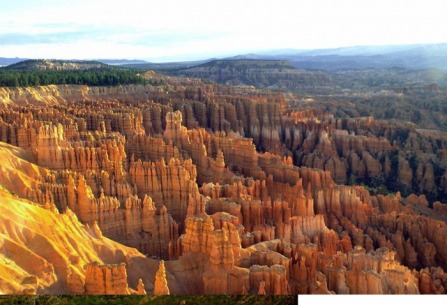
Bryce Canyon National Park
Visitor Center
Operating Hours
Summer 8am - 8pm (May - September)
Fall (October) 8:00 am - 6:00 pm
Winter (November - March) 8:00 am - 4:30 pm
Spring (April) 8:00 am - 6:00 pm
Phone
435/834-5322
Location
4.5 miles south of the intersection of Hwy. 12
The entrance fee to Bryce Canyon National Park is $25 per private vehicle. The fee for an individual entering by foot, bicycle, motorcycle, or non-commercial group is $12.00 per person.
Bryce Canyon NP Travel Guide
A land that captures the imagination and the heart, Bryce is a visitor favorite among Utah's national parks. The park was named for Ebenezer Bryce, a pioneer cattleman and the first permanent settler in the area. His description of the landscape not being hospitable to cows has oft been repeated. Even more than his famous quote, however, Bryce Canyon is known for its fanciful "hoodoos," best viewed at sunrise or sunset, when the light plays off the red rock.
In geological terms, Bryce is actually an amphitheater, not a canyon. The hoodoos in the amphitheater took on their unusual shapes because the top layer of rock -- "cap rock" -- is harder than the layers below it. If erosion undercuts the soft rock beneath the cap too much, the hoodoo will tumble. But Bryce will never be without hoodoos, because as the amphitheater's rim recedes, new hoodoos are formed.
Bryce Canyon in One Day
Begin your day at the visitor centerto get an overview of the park and to purchase books and maps. Watch the video and peruse exhibits about the natural and cultural history of Bryce Canyon. Thus informed, drive to the historic Bryce Canyon National Park Lodge. From here, stroll along the relaxing Rim Trail. Afterward, drive the 18-mi Main Park Road , stopping at the overlooks along the way. Allowing for traffic, and if you stop at all 13 overlooks, this drive will take you between two and three hours.
If you have the time and energy for a hike, the easiest route into the amphitheater is the Queen's Garden Trailat Sunrise Point. A short, rolling hike along the Bristlecone Loop Trail at Rainbow Point rewards you with spectacular views and a cool walk through a forest of bristlecone pines. If you don't have time to drive the 18 mi to the end of the park, skip Bryce Canyon National Park Lodge and drive 2 mi from the visitor center to Inspiration Point and the next 2 mi to Bryce Point.
End your day with sunset at Inspiration Point and dinner at Bryce Canyon National Park Lodge (you'll want to have made your reservations that morning). As you leave the park, stop at Ruby's Inn for Native American jewelry, souvenirs for the kids, and snacks for the road.
Main Park Road
Rate It
Map It
* Category: Scenic Drives
* Location: Bryce Canyon NP
Fodor's Review:
One of the delights of Bryce Canyon National Park is that much of the park's grandeur can be experienced from scenic overlooks along its main thoroughfare, which meanders 18 mi from the park entrance south to Rainbow Point. Allow two to three hours to travel the entire 36 mi round-trip. The road is open year-round, but may be closed temporarily after heavy snowfalls to allow for clearing. Major overlooks are rarely more than a few minutes' walk from the parking areas, and many let you see more than 100 mi on clear days. All overlooks lie east of the road -- to keep things simple (and left turns to a minimum), you can proceed to the southern end of the park and stop at the overlooks on your northbound return. Trailers are not allowed beyond Sunset Campground. Day users may park trailers at the visitor center or other designated sites; check with park staff for parking options. RVs can drive throughout the park, but vehicles longer than 25 feet are not allowed at Paria View.
Camping
North Campground
(At least one loop is open year round*)
North Campground is located across the road to the east of the Bryce Canyon Visitor Center and is comprised of 107 sites in 4 loops; A, B, C, D. Cost is $15 per site/per night.
32 sites are reservable during certain times of the year (See Reservation Dates below). Cost is $15 per site/per night.
North campground is closest to the general store. Loops A & B are for RV campers. Loops C & D are for tent campers.
There are no sewer, water or electrical hook-ups available. A dump station is available south of the campground for a $2 use fee.
Reservation Dates:
2009 - May 8-September 27
2010 - May 7-September 26
To make reservations for 32 sites call (877) 444-6777 or click
(Closed in winter)
Sunset Campground is located west of Sunset Point, approximately 1.5 miles south of the Bryce Canyon Visitor Center, and is comprised of 101 sites in 3 loops; A, B, & C.
All sites are available on a first-come, first-served basis. Reservations are not accepted. Cost is $15 per site/per night.
Loop A is for RV campers. Loops B & C are for tent campers. Two wheelchair-accessible sites are located in Loop A.
This campground is closest to the best hiking trails which begin and end at Sunset Point.
RV and trailer combinations over 45 feet are discouraged, but not prohibited.
There are no sewer, water or electrical hook-ups available. A dump station is available at North Campground for a $2 use fee.
Day Nineteen
Capitol Reef National Park
Vehicles: $5.00 (Good for 7 days) This fee applies to private vehicles, including motorcycles.
Visitor Center will open daily at 8 a.m. and close at 6 p.m
Capitol Reef National Park Travel Guide
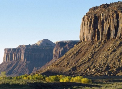
Your senses will be delighted by a visit to Capitol Reef National Park. Here, the land is saturated in colors that are more dramatic than anywhere else in the West. The dominant Moenkopi rock formation is a rich, red-chocolate hue. Deep blue-green juniper and pinyon stand out against it. Other sandstone layers are gold, ivory, and lavender. Sunset brings out the colors in an explosion of copper, platinum, and orange, then dusk turns the cliffs purple and blue. The texture of rock deposited in ancient inland seas and worn by subsequent erosion is pure art. The park preserves the Waterpocket Fold, a giant wrinkle in the earth that extends a hundred miles between Thousand Lake Mountain and Lake Powell. When you climb high onto the rocks or into the mountains, you can see this remarkable geologic wonder and the jumble of colorful cliffs, massive domes, soaring spires, and twisting canyons that surround it. It's no wonder Native Americans called this part of the country the "land of sleeping rainbow."
But your eyes will not be alone in their joy. The fragrance of pine and sage rises from the earth, and canyon wrens sing to you as you sit by the water. Flowing across the heart of Capitol Reef is the Fremont River, a narrow little creek that can turn into a swollen, raging torrent during desert flash floods. The river sustains cottonwoods, wildlife, and verdant valleys rich with fruit. During the harvest, your sensory experience is complete when you bite into a perfect ripe peach or apple from the park's orchards. Your soul, too, will be gratified here. You can walk the trails in relative solitude and enjoy the beauty without confronting crowds on the roads or paths. All around you are signs of those who came before: ancient Native Americans of the Fremont culture, Mormon pioneers who settled the land, and other courageous explorers who traveled the canyons. It is a rare thrill to feel the past overtake the present.
Capitol Reef in One Day
Pack a picnic lunch, snacks, and cold drinks to take with you, because there are no restaurants in the park. As you enter the park, look to your left for Chimney Rock; in a landscape of spires, cliffs, and knobs, this deep-red landmark is unmistakable. Start your journey at the visitor center , where you can study a three-dimensional map of the area, watch the short slide show, and browse the many books and maps related to the park. Then head for the park's scenic drive, stopping at the Fruita Historic District to see some of the sites associated with the park's Mormon history. Stop at the Historic Gifford Farmhouse for a tour and a visit to the gift shop. As you continue on with your tour, check out the Fremont Indian Petroglyphs, and if you feel like some exertion, take a hike on the Hickman Bridge Trail. Next you'll have to backtrack a few miles on Highway 24 to find the Goosenecks Trail . At the same parking lot you'll find the trailhead for Sunset Point Trail; take this short hike in time to watch the setting sun hit the colorful cliffs
Utah Scenic Byway 12
Rate It
* Category: Scenic Drives
* Location: Capitol Reef National Park
Fodor's Review:
Named as one of only 20 All-American Roads in the United States by the National Scenic Byways Program, Highway 12 is not to be missed. The 32-mi stretch between Torrey and Boulder winds through alpine forests and passes vistas of some of America's most remote and wild landscape. It is not for the faint of heart or those afraid of narrow, winding mountain roads.
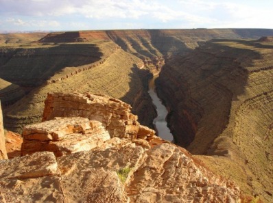
Canyonlands National Park
Island in the Sky Park Road
Rate It
* Category: Scenic Drives
* Location: Canyonlands National Park
Fodor's Review:
This 12-mi long road connects to a 5-mi side road to the Upheaval Dome area. You can enjoy many of the park's vistas by stopping at the overlooks -- get out of your car for the best views. Once you get to the park, allow about two hours to explore.
Needles District Park Road
Rate It
* Category: Scenic Drives
* Location: Canyonlands National Park
Fodor's Review:
You'll feel certain that you've driven into a picture postcard as you roll along the park road in the Needles District. Red mesas and buttes rise against the horizon, blue mountain ranges interrupt the rangelands, and the colorful red and white needles stand like soldiers on the far side of grassy meadows. The drive, about 10 mi one way, takes about half an hour.
Scenic Drive
The Island in the Sky offers the best opportunities for sightseeing by car. The overlooks along the scenic drive are perched 1,000 feet above the surrounding terrain, providing spectacular views of the canyons below as well as the other districts. Several short trails, including Mesa Arch, Upheaval Dome and Aztec Butte, lead to interesting natural and cultural resources. Plan on spending at least an hour in the park in order to drive out to Grand View Point. More time is needed to enjoy the other overlooks or explore some of the short trails.
Four-Wheel Driving
There are hundreds of miles of four-wheel-drive roads in Canyonlands, providing access to various campsites, trailheads and viewpoints in the park's backcountry. These roads range in difficulty from intermediate, like the White Rim Road at the Island in the Sky, to extremely technical routes like Elephant Hill in the Needles and the road to the Land of Standing Rocks in the Maze.
Canyonlands National Park
Short Hikes at the Island
photo: Hikers on the Grand View Point Trail
NPS Photo by Neal Herbert
Hikers on the Grand View Point Trail
Several short trails exist along the scenic drive at the Island. These include Aztec Butte, Grand View Point, Mesa Arch, Whale Rock and Upheaval Dome (to the first overlook). Each of these trails highlights some aspect of the park’s natural or cultural history. Guides are available for some of the trails at trailheads and in the visitor center.
Aztec Butte Trail
Length: 2 mi/3 km round-trip
Start: Aztec Butte parking area
Time: 1.5 hours
Elevation Change: 225 ft/69 m
A steep climb up a slickrock dome leads to some ancestral Puebloan granaries and outstanding views of Taylor Canyon.
Grand View Point Trail (see photo above)
Length: 2 mi/3 km round trip
Start: Grand View Point
Time: 1 hour
An easy walk out to the very end of the Island in the Sky mesa. Panoramic views.
Mesa Arch
Length: .5 mi/.8 km round trip
Start: Mesa Arch parking area
Time: 30 minutes
A mild walk out to an arch perched right on a cliff edge. A great sunrise hike.
Upheaval Dome Overlook Trail
Length (round-trip): 1 mi/1.5 km to first overlook
Start: Upheaval Dome parking area
Time: 30 minutes
Elevation Change: 50 ft/15 m
Good view of a very intriguing rock formation. Hiking to the second overlook adds 1 MI/1.5 km and at least 15 minutes.
Whale Rock Trail
Length (round-trip): 1 mi/1.5 km to main overlook
Start: Near Upheaval Dome parking area
Time: 1 hour
Elevation Change: 100 ft/30 m
Handrails provided for the steep climb up Whale Rock. Good views of upheaval dome area.
Arches National Park
Arches is open year-round, 24 hours a day. The visitor center is open daily during the following hours:
April through October: 7:30 a.m. to 6:30 p.m.
November through March: 8:00 a.m. to 4:30 p.m.
Vehicles: $10 (Good for 7 days)
This fee includes all occupants of a vehicle
Arches National Park Travel Guide
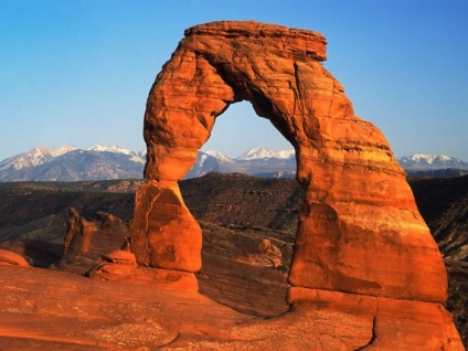
The red rock landscape of Arches National Park awakens the spirit and challenges the imagination: balanced rocks teeter unthinkably on pedestals; sandstone arches -- of which there are more than 2,000 -- frame the sky with peekaboo windows; and formations like the Three Penguins greet you at points throughout the 73,379-acre park. Far from a stereotypical beige-tone palette with the occasional cactus, the desert here is adorned with a rich tapestry of colors: red, orange, purple, pink, creamy ivory, deep chocolate, and even shades of turquoise. The Fiery Furnace burns like a wildfire at sunset, and acres of petrified sand dunes rise across the horizon.
The sky is big here, so it's easy to spot many of the arches from your car. But despite the endless horizon, you should really step outside and walk beneath the spans and giant walls of orange rock. This gives you a much better idea of their proportion. No doubt you will feel as writer Edward Abbey did when he awoke on his first day as a park ranger in Arches: that you're walking in the most beautiful place on Earth.
Arches in One Day
Start early, while the day is still cool, with a 3-mi round-trip hike on the Delicate Arch Trail . The route is strenuous but richly rewarding. Pause for a healthy snack before heading for Landscape Arch, the second of the park's two must-see arches. To get there you must hike through Devils Garden, a great spot for morning photography. If you're accustomed to hiking you might next hike out to Double O, a trip that is well worth the effort but that can be tough after the hike to Delicate Arch -- especially in July or August. If you do hike to Double O, take your lunch with you and have a picnic in the shade of a juniper or in a rock alcove. Don't forget to pack out every scrap of paper and food. By the time you return you'll be ready to see the rest of the park by car, with some short strolls on easy paths.
In the mid- to late afternoon, drive to Balanced Rock for photos, then on to The Windows. Wander around on the easy gravel paths for more great photo ops. Depending on what time the sun is due to set, go into town for dinner before or after you drive out to Delicate Arch or the Fiery Furnace and watch the sun set the rocks on fire.
Delicate Arch
Rate It
* Address: 13 mi from the park entrance, 2 1/5 mi off the main road, Arches National Park, UT
* Category: Geological Sites
* Location: Arches National Park
Fodor's Review:
The familiar symbol of Arches National Park, if not for the entire state of Utah, Delicate Arch is tall enough to shelter a four-story building. The arch is a remnant of an Entrada sandstone fin; the rest of the rock has eroded and now frames the La Sal Mountains in the background. You can drive a couple of miles off the main road to view the arch from a distance, or you can hike right up to it. The trail is a moderately strenuous 3-mi round-trip hike.
If You Like to Hike
Time allocations are based on an average hiking speed of two miles per hour, and include time to drive to the trailheads. (Time spent marveling and contemplating the majestic wonders and sights varies greatly and is not included here.) Add time to take in the scenery from roadside pullouts between destinations.
In two hours, you can do one of these four routes:
* Hike the Windows loop trail and get an up-close view of the North and South Windows and Turret Arch. Then take the short trail between parking areas and hike up to Double Arch. Drive back to Balanced Rock and take the loop trail around its base. Contemplate its precarious position as you walk beneath it.
* Take the Delicate Arch Trail from Wolfe Ranch up the sloping slickrock to stand under the best known arch in the world. (During hot months, do this hike early or late in the day.)
* Hike between the tall sandstone fins in the Devils Garden to see Landscape Arch, perhaps the world’s longest. How long will this thin span resist the forces of gravity?
* Walk to Sand Dune Arch, across the grassy field and onward to Broken Arch. Continue around the loop, through the end of the campground, and return. Enjoy the vista toward the distant Book Cliffs, the beautiful Tapestry Arch and the sandstone fins.
In half a day, take one of these three hikes:
* Hike the entire Devils Garden Trail, all the way out to the spire called Dark Angel. When you return, take the primitive loop.
* Take the moderately strenuous ranger-guided hike through the the Fiery Furnace. Sign up ahead of time at the visitor center.
* If you don’t mind driving the rough and often “washboard” road to the remote island of rock known as Klondike Bluffs, hike the primitive trail to Tower Arch. If you have a whole day or more, combine the above hikes to fill the time you have.
If You Like to Tour by Car
In 1 1⁄2 hours you can take one of the following routes:
* Drive to the Windows Section and see some of the park’s largest arches. (Add one-half hour to stroll beneath either North Window or Double Arch.)
* Drive to the Delicate Arch Viewpoint and see the world’s most famous arch, a mile distant. Stop at Wolfe Ranch on your way back and imagine what it would have been like to homestead this relatively barren area in the late 1800s. Three hours will give you time to do both drives. (Or you could do one drive, spending ten minutes at each viewpoint along the way.)
If you have 4 1⁄2 hours:
You could drive all of the paved park roads, spending ten minutes at each viewpoint, and take quick drives to the Windows Section, Wolfe Ranch, and Delicate Arch Viewpoint.
Camping
Big Mesa BLM State: Utah Nearest City: Moab Nearest Town: Moab Cost: Free Number of Campsites: 11-29 Max days allowed: 14 Road: Dirt Miles from paved road: 0.25 Scenery Rating: 5 out of 5 Noise Level: 1 out of 5 Amenities: None Status: Official Months Open: Year Round Description From the intersection of 191 & 128 (right where 191 crosses the Colorado River just north of Moab), drive about 7 miles north on 191. Turn left on 313, following the sign toward Canyonlands National Park and Dead Horse Point State Park. The campground is about 8 miles down on the right. If there's anyone else in the campground, you'll be able to see RVs perched on the mesa up ahead on the right as you approach. You'll then come to a viewpoint on the left. Immediately after the viewpoint entrance, turn right on the unmarked gravel road. Go about 300' and turn right at the Big Mesa Campground sign onto the dirt entrance road. As the name implies, this campground sits on top of a huge open mesa, and has sweeping views of the area around Arches and Canyonlands National Parks, and the snow-capped (at least in May) La Sal Mountains to the east. A wall of blazing red sandstone borders the northern edge of the campground. There's lots of room for any size rig, and plenty of space between the sites for privacy and quiet. The only thing you have to deal with is a pretty rough dirt entrance road. So take it slow for that 1/4 mile, then sit back and enjoy the spectacular scenery. Note: self-contained RVs or portable toilets are required here. You are now in the heart of red-rock country with both Arches & Canyonlands right nearby, along with tons of other opportunities for hiking, biking, jeep and ATV trails, rafting, etc. Enjoy!
Ken's Lake State: Utah Nearest City: Moab Nearest Town: Moab Cost: $10 or less Number of Campsites: 30 or more Max days allowed: 14 Road: Gravel Miles from paved road: 1.00 Scenery Rating: 5 out of 5 Noise Level: 2 out of 5 Amenities: None Status: Official Months Open: Unknown Description Ken's Lake is a few miles south of the edge of Moab. This is a BLM campground on Ken's Lake that charges $10/night. There are 31 gravel pads, no water, electric or dump. There are several pit toilets. Go south on US-191, turn east on Old Airport Road, turn south on Spanish Valley Road, and turn left onto gravel road indicated by BLM sign for Ken's Lake campground.
The Devils Garden Campground is located eighteen miles from the park entrance and is open year-round. Facilities include potable water, picnic tables, grills, as well as both pit-style and flush toilets. There are no showers. Bring your own wood or charcoal for the grills. Some sites will accommodate RV's up to 30 feet in length. Telephone and on-line reservations for both group and individual sites may be made through
Individual Sites
The campground has 52 individual sites which are $20 per night and will accommodate up to ten people. Up to 28 of the individual sites may be reserved for nights between March 1st and October 31st. Reservations must be made no less than 4 days and no more than 180 days in advance. There is an additional $9 booking fee for reservations. To make a reservation, visit
The remaining 24 campsites are available on a first-come, first-served basis each day beginning at 7:30 a.m. at the park entrance station or visitor center. Keep in mind that not all sites become available each day.
Day Twenty
Colorado National Monument
Colorado National Monument Visitor Center is an excellent place to start your trip. A 12-minute program orients the visitor to the monument and the area. The visitor center also has exhibits and a bookstore, as well as restrooms.
Book Cliffs Overlook
This unique shelter is on the National Register of Historic Places. It provides a wonderful view of Wedding Canyon and the Grand Valley. Weddings have been held here for generations. Check out our Permits page for information on hosting your wedding or ceremony here.
Rim Rock Drive
A 23-mile scenic drive will lead you along the rim of a colorful panorama of deep, sheer-sided canyons, and high rock towers. Wayside exhibits at pullouts along the drive provide information about the natural and human history of the park. Allow 45 minutes of driving time, plus additional time for walking, photography, or stopping at pullouts.
Black Canyon of the Gunnison
South Rim Road
The South Rim Drive is 7 miles from Tomichi Point to High Point, and has 12 overlooks. Most are reached by walking a short trail. Allow 2-3 hours to view several overlooks. Those with limited time should consider stopping at Gunnison Point, Chasm View, Painted Wall and Sunset View.
The South Rim Visitor Center, which features exhibits on the canyon, is located at Gunnison Point. The visitor center is open daily throughout the summer, and most days of the week the rest of the year. The South Rim Road beyond Gunnison Point is closed to vehicles in winter.
North Rim Road
The North Rim is reached by taking a gravel road from the east end of Crawford State Park. The North Rim Road provides access to 6 overlooks. The canyon walls on the North Rim are almost vertical, offering some of the most impressive views found in the national park. Allow 2-3 hours for a leisurely tour.
Information is available at the North Rim Ranger Station, open intermittently in summer. The North Rim Road is closed in winter.
East Portal Road
NPS photo by Lisa Lynch
Aerial view of East Portal Road.
East Portal Road
Those wishing to drive to the Gunnison River may do so by taking the East Portal Road. This provides access into Curecanti National Recreation Area where camping, picnicking and fishing are available. East Portal Road is closed in winter.
The road is extremely steep (16% grades) with hairpin curves. Vehicles with an overall length (including trailer) greater than 22 feet are prohibited on the East Portal Road. Trailers may be left unhitched and left at a parking area at the campground entrance.
Another access, located at Cimarron (18 miles east via Highway 50), provides an alternative drive to the Gunnison River (and Curecanti National Recreation Area).
Hiking Trails
Many trails pass by steep dropoffs, so be cautious and keep a close watch on children.
Hikers should be aware that limited cattle grazing is permitted on the North Rim. Please keep cattle gates closed should you encounter them.
SOUTH RIM
Rim Rock Nature Trail
Moderate - 1 mile round trip
As its name implies, this self-guided nature trail takes you along a relatively flat path following the rim of the canyon. Along this sunny route you will encounter a variety of plant life from sagebrush and Gambel oak to pinyon pine and Utah juniper. This trail allows many excellent views of the Gunnison River as well as the sheer walls of the canyon.
The trailhead is near the entrance to Campground Loop C and ends at the Tomichi Point Overlook.
Oak Flat Loop Trail
Strenuous - 2 miles round trip
The Oak Flat Loop Trail (built by Student Conservation Association volunteers) offers variety to the hiker who would like to explore below the rim without taking on the challenge of hiking to the river. Parents should be aware that the trail is narrow in places and traverses some steep slopes.
The trail begins near the Visitor Center. Go a short distance to the Oak Flat Loop/River Access sign and follow the trail which leads right. Descend through a grove of aspen to another signed junction. Turn left here to continue on the Oak Flat Loop. The trail meanders through a thicket of oak scrub (Gambel oak) passing near a rock outcrop, a pleasant location where you can relax and enjoy the view. The trail then heads west where it begins its ascent through a forest of Douglas fir, Aspen, and Gambel oak. On the return leg one encounters another unmarked overlook offering spectacular views downstream. Pets are not allowed.
Cedar Point Nature Trail
Easy - 2/3 mile round trip
An excellent place for one to brush up on the local flora, this short, sunny, moderately sloped trail offers guideposts describing the various plants along the way. At the end are two overlooks offering breathtaking views of the river over 2,000 feet below. Also visible is the famous Painted Wall, the tallest cliff in Colorado (2,250 ft.), as well as rock islands jutting up from the depths of the canyon.
Warner Point Nature Trail
Moderate - 1.5 miles round trip
You can pick up a trail guide at the High Point Overlook or the South Rim Visitor Center. Along this trail you will find shady benches which allow you to rest among mountain mahogany, serviceberry, pinyon pine, and juniper. Looking south you can see the San Juan Mountain Range, Uncompahgre Valley, and Bostwick Park. To the north look for the West Elk Mountains, and at the end of the trail enjoy the views of the Gunnison River and the Black Canyon. Pets are not allowed.
Warner Point Nature Trail Guide (3MB pdf)»
NORTH RIM
Chasm View Nature Trail
Moderate - 1/3 mile round trip
This trail is located at the end of the one-way campground loop. After a short distance, the trail breaks out of the pinyon/juniper forest at the North Chasm View, some 1800 feet above the river. Continuing near the rim, the trail reaches a second overlook with excellent views of Painted Wall and Serpent Point. Keep a lookout for swifts, swallows and raptors frequently seen from this overlook. The people you can see on the far side, at Chasm View overlook are only 1,100 feet away.
North Vista Trail
Moderate to Exclamation Point - 3 miles round trip
Strenuous to Green Mountain - 7 miles round trip
Constructed by volunteers for Outdoor Colorado, the North Vista Trail offers some of the best scenic views and birding in the Park.
Start this trail at the North Rim Ranger Station. After passing through an area of sage and oak brush, the trail meanders in a pinyon/juniper forest along the canyon’s rim. Several overlooks offer views of SOB draw and the inner canyon. At Exclamation Point some of the best inner-canyon views can be found. Those continuing to Green Mountain will be rewarded by panoramic vistas, including the San Juan Mountains, the West Elks, Grand Mesa, the Uncompahgre Plateau, and an aerial perspective of the Black Canyon.
Deadhorse Trail
Easy to moderate - 5 miles round trip
This trail offers good views of Deadhorse gulch and East Portal on the Gunnison River, as well as good birding.
Park at the Kneeling Camel Overlook and walk a few yards east to a spur road that leads to the old Ranger Station. The trail, actually an old service road, begins here. After 3/4 of a mile the road passes a stock pond. This pond is fed by one of the few springs found on the rim of the Black Canyon. Continue on another 1 1/2 mile until you encounter a stock fence. Turn right (south) here and walk 1/4 mile along the fence until you come to the canyon’s rim. Deadhorse Gulch is the large side drainage located just east of the overlook (and the fence).
Pike's Peak
Towering 14,110 feet above Colorado Springs, this mountain serves as one of the nation's most famous landmarks. Access to the summit can be obtained via the Pike's Peak Cog Railway , or by driving the Pikes Peak Highway which winds through stands of pine and aspen before cresting above treeline. Katherine Lee Bates was so moved by her visit to the summit that it inspired her to pen "America the Beautiful." Bring a jacket as the temperature is about 20 degrees cooler up top.
Camping
Oak Creek Campground State: Colorado Nearest City: Colorado Springs Nearest Town: Cañon City Cost: Unknown Number of Campsites: 11-29 Max days allowed: 60 Road: Gravel Miles from paved road: 12.00 Scenery Rating: 5 out of 5 Noise Level: 1 out of 5 Amenities: Restrooms Status: Official Months Open: Year Round Description Nice Forest Service campground in the San Isabel National Forest. Primitive, has outhouses, firepits and picnic tables.
Cottonwood Pass Road State: Colorado Nearest City: Colorado Springs Nearest Town: Buena Vista Cost: Free Number of Campsites: 30 or more Max days allowed: Unknown Road: Dirt Miles from paved road: 0.00 Scenery Rating: 3 out of 5 Noise Level: 2 out of 5 Amenities: None Status: Unoffical Months Open: 7-8 Description About 10 miles west of Buena Vista on County Road 306, there is a National Forest campground on the right side of the road. Across the road is a pleasant wooded area next to a creek where camping is free. The road doesn't have much traffic. All amenities are available across the road in the National Forest parking lot.
Day Twenty One
Kansas City

All I can say is BBQ
St. Louis
Just for the Arch
